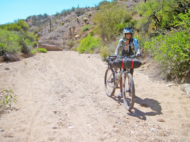
When Nancy and I started into the bikepacking thing last year. We had this remote thought that maybe we'd do the AZT300 (https://aztrail.home.blog/). It seemed a stretch, but what fun is life if you aren't testing the boundries. Well, it was a stretch - but we did not break. We finished - and met or exceeded my "stretch goals" for each day. This was the toughest thing I've ever done, but so rewarding. Below is a recap of how it went down.
Day 0
One of the biggest logistical hurdles in this event is the whole shuttle thing. It is a big thing to ask someone to schlepp you all the way down to Parker Canyon, then pick you up in Superior - at a time to be defined in the future. Fortunately, Ray made this all easy by arranging a shuttle (van + enclosed trailer for bikes) from Picket Post (finish line) down to Parker Canyon Lake (starting line) the night before the race. We ended up having 11 racers on the shuttle. We all gathered Thursday night for a 5:30pm departure. Stopped in Tucson (at 1702) on the way down for some pizza and beer. Last decent meal we’d have for a while. We arrived at the lake some time around 9pm. We all just found a spot somewhere and crashed for the night. No messing around.

Discussing strategy as the bikes get loaded up
Day 1
The “official” race start was 9am Friday morning. Nancy and I decided that we wanted to get going by 6am since our goal for the day was quite far and we’d heard that the first 30 miles of this were pretty tough. We started our day out by waking up with the sun already rising. Nancy’s alarm didn’t ring at 5am like it should have. We scrambled to get our stuff packed and shoved down a little food – no time for cooking. We actually hit the trail right at 6am – everyone else was still in their bags.

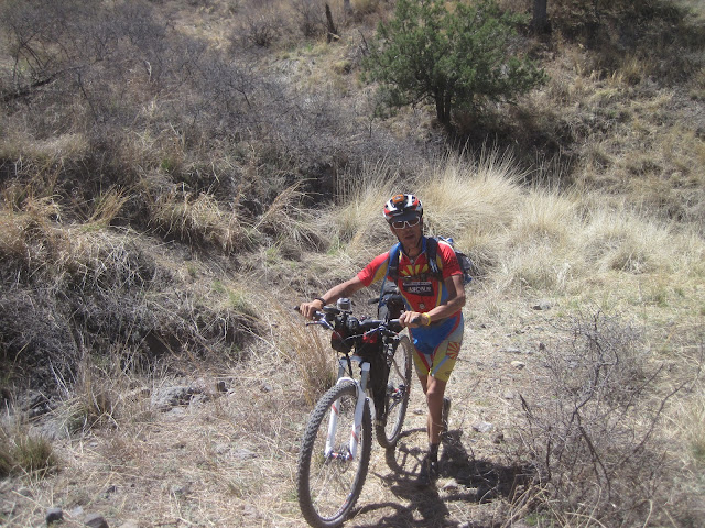
The trail started out a little rocky, but a mostly downhill slope. The sun was coming up and it looked to be another beautiful day. Eventually, the trail started rolling up and down through the Canelo Hills and the trail surface was rather rocky and loose. Even where the trail was not super steep it was loose enough that we just weren’t able to climb with singlespeeds. The hike-a-bike (HAB) had begun. Somewhere in there we saw Max come ripping by. He was feeling really good and was tearing it up. The Canelo Hills segment is about 30 miles and ends up at the town of Patagonia. I had heard stories about how difficult it is and how much HAB is required – the stories were not exaggerated. This section took us over 7 hours!


When we hit Patagonia, we had a 12 mile spin on the road to Sonoita. That was our first resupply stop. Got some lunch and food for later. Nancy got yelled at by the owner because she closed the door on a food case a little too hard - whatever. The lady at the little store across the street was way nicer. She found a little compact mirror for Nancy so she could take her contacts out and put them in each day - that was one of those small, essential items that got overlooked on the packing list. We started seeing a bunch of the faster folks (like Eszter) who started at 9:00 at this stop. We rode out of Sonoita with Ray for a while until he decided to quit slumming and charged off. Next was a little pavement, then some dirt roads. It was nice to do some easy miles while digesting the huge amount of food I had just consumed.

Eventually we got back on the AZT and rolled some really amazing sections of trail into Kentucky Camp. This is a first night stop for a lot of people since it has water and a bathroom. However, we had planned to go further. Out of Kentucky Camp we climbed up some dirt roads. I was in front on a section and heard an engine on an SUV screaming. A kid came whipping around the corner (a World Rally Cup driver in his mind) and nearly ran me down. I yelled a few choice words at him and his reply was “I’ve got a gun”. Yeah, we are in rural Arizona alright. Fortunately he did not even pause to show me this gun. It was time for us to get off the road and do some climbing and then a nice descent. At the bottom of the decent it was time to put on lights. Pulled out my battery and realized that the extension cord was attached to the charger, on my desk at home. So I ended up gorilla taping the battery to the helmet. Thankfully, it was not heavy like the lead acid batteries we used to use in the old days, but it did tend to make my neck sore after a few hours. We continued on some more sections of really nice trail and eventually made it to a big canyon. We knew that the next few miles were pretty tough, so decided to stop for the night.


3 racers in their bivys dreaming of pedalling the AZT
The trail started out a little rocky, but a mostly downhill slope. The sun was coming up and it looked to be another beautiful day. Eventually, the trail started rolling up and down through the Canelo Hills and the trail surface was rather rocky and loose. Even where the trail was not super steep it was loose enough that we just weren’t able to climb with singlespeeds. The hike-a-bike (HAB) had begun. Somewhere in there we saw Max come ripping by. He was feeling really good and was tearing it up. The Canelo Hills segment is about 30 miles and ends up at the town of Patagonia. I had heard stories about how difficult it is and how much HAB is required – the stories were not exaggerated. This section took us over 7 hours!

Beautiful, but dangerous - just like the AZ desert.

There was plenty of hike-a-bike

I joined in the fun

But then there was some of this as well

Max killing it
When we hit Patagonia, we had a 12 mile spin on the road to Sonoita. That was our first resupply stop. Got some lunch and food for later. Nancy got yelled at by the owner because she closed the door on a food case a little too hard - whatever. The lady at the little store across the street was way nicer. She found a little compact mirror for Nancy so she could take her contacts out and put them in each day - that was one of those small, essential items that got overlooked on the packing list. We started seeing a bunch of the faster folks (like Eszter) who started at 9:00 at this stop. We rode out of Sonoita with Ray for a while until he decided to quit slumming and charged off. Next was a little pavement, then some dirt roads. It was nice to do some easy miles while digesting the huge amount of food I had just consumed.

Was nice to ride with Ray for a little bit
Eventually we got back on the AZT and rolled some really amazing sections of trail into Kentucky Camp. This is a first night stop for a lot of people since it has water and a bathroom. However, we had planned to go further. Out of Kentucky Camp we climbed up some dirt roads. I was in front on a section and heard an engine on an SUV screaming. A kid came whipping around the corner (a World Rally Cup driver in his mind) and nearly ran me down. I yelled a few choice words at him and his reply was “I’ve got a gun”. Yeah, we are in rural Arizona alright. Fortunately he did not even pause to show me this gun. It was time for us to get off the road and do some climbing and then a nice descent. At the bottom of the decent it was time to put on lights. Pulled out my battery and realized that the extension cord was attached to the charger, on my desk at home. So I ended up gorilla taping the battery to the helmet. Thankfully, it was not heavy like the lead acid batteries we used to use in the old days, but it did tend to make my neck sore after a few hours. We continued on some more sections of really nice trail and eventually made it to a big canyon. We knew that the next few miles were pretty tough, so decided to stop for the night.

It is a particularly good year for desert flowers

This is such a fun section.
Stats for the day: 14.5 hours, 72 miles, 9157 feet of climbing
Day 2
Since we were at about 4600 feet, it was pretty chilly first thing in the morning, so I didn’t feel so bad about having to grind through the next section of hills. About a mile or two down the trail we ran into Mark and Josiah who were just breaking camp. We'd ride with them on and off throughout most of the race. It was always nice to see them. The hilly HAB section of trail opened up into a VERY fun, mostly downhill section. This was a joy to ride and took us all the way down to I-10, near Tucson. We ran into Mark who was repairing a cut in the sidewall of his tire. One of the big deals out here is how abusive the environment is on tires. Most of us run Nevegals or Rampages or other tires like that which we believe will take the abuse. I talked to people with both of those tires who had slices during the ride. While Nancy and I with our Continentals (with “protection” sidewalls) were fine. If someone would invent a tire with a truly tough sidewall (under 900 grams), it would sell VERY well out here.

Anyhow, we rolled on past Colossal Cave through some tough, but fun trails. Stopped at a campground to get water and, of course, Mark and Josiah were already there. After that was a little climbing and then a long, smooth, fast, rolling section – so much awesome. Eventually Saguaro National Forest got in the way and we had to dump out onto the road . This ran us past Rincon Market, which is a standard stopping place since it is the last resupply before Oracle. We met up with a number of other riders here. Mark and Josiah were there of course. The microwave hamburger was surprisingly not horrible. By this time it was getting hot. We got a gallon of water and Nancy filled her bottles and pack. I took what was left but my bottles and pack were not full. I then made the crucial mistake of not getting more water.

After the market we took some more roads, then a ridiculous sandy section of trail. This took us to a dirt road climb up into the mountains. Right from the start of the climb I was feeling the heat. And so was Josiah. The two of us suffered up the dirt road until it turned off onto one of the worst jeep roads I’d ever seen. These included stupidly steep ups and downs – making the climb up the mountain that much harder. Not only was the heat and the climb killing me, I realized that my water was going fairly quick. Why did I not get more water at Rincon?!? Somehow we made it to the top of the climb and back to Reddington road. Crossed the road and decided it was time for lights. At this point I drank the Gatorade I had brought with me for dinner and had about a bottle of water left.


These cows were actually eating the prickly pear.
Anyhow, we rolled on past Colossal Cave through some tough, but fun trails. Stopped at a campground to get water and, of course, Mark and Josiah were already there. After that was a little climbing and then a long, smooth, fast, rolling section – so much awesome. Eventually Saguaro National Forest got in the way and we had to dump out onto the road . This ran us past Rincon Market, which is a standard stopping place since it is the last resupply before Oracle. We met up with a number of other riders here. Mark and Josiah were there of course. The microwave hamburger was surprisingly not horrible. By this time it was getting hot. We got a gallon of water and Nancy filled her bottles and pack. I took what was left but my bottles and pack were not full. I then made the crucial mistake of not getting more water.

Rincon Market - biker hangout

Riding into the sunset
Mark and Josiah and Holt were just heading out to do more climbing from Reddington. A couple of minutes later we came upon Josiah laying on the ground dry heaving. He was not doing well. Caught up with Mark and Holt – who were checking out an angry rattler and told them the situation. Mark went back and Holt went on. We continued on in a climbing section, followed by some nice downhills – very scenic with the sun setting. By this time I was running very low on water and my mouth was quite dry. I knew there was a little stream ahead – I had been there last month and there was water. I pushed Nancy hard through the darkness (sorry babe) – dreaming of laying down in the cool water. It took forever, but we finally got there – the stream was dry. Ugh. Nancy gave me one of her water bottles since she had some extra water. I knew that there was a “reliable” spring up near the campground at Molino. However, I also knew that there was a hellacious climb to get to it. We felt like we had no choice – I had to have water. So we pressed on. The climb up to Molino was easily the worst contiguous section of trail I’ve ever pushed a bike up. The worst part was the last half mile or so that went up 500 feet. It was all ledges and drops and pushing our bikes up and over large rocks. Nancy was suffering nutritionally and I was suffering hydrationally on this section. This is a favorite of downhillers – but they go down it. Going up is insanity. After what seemed like hours of suffering, we finally made it to the top. However, we still had to descend the chunky trail on the other side. I got down first and found Holt and another guy looking for the spring that was supposed to be there. I had a waypoint marked on my GPS and we went up a wash looking for this spring. Other than a 6 inch diameter pool of brackish water, there was no moisture to be found. I was not a happy camper and was getting rather concerned. We went across the road to Molino campground (which does not have water) and was about to knock on the camp steward’s door (at 10pm) to beg for water, when we noticed that there were some folks camping who were still up. We went over and offered them money for water. I had a $20 bill which I would have gladly exchanged for two water bottles full. They were very nice and just happened to have a 10 gallon jerry can of water. Nancy, Holt and I fill up. Survival! We got a real camp spot – with a table and everything and dined on Ramen and tuna. Such luxury.
Stats for the day: 15.5 hours, 80.5 miles, 9500 feet of climbing, unmeasurable suffering
Day 3
Started with a 2 mile climb on semi chunky trail to the Prison Camp campground. We saw Mary Renolds there. She is a journalist who writes about outdoorsy stuff in Tucson. She interviewed Nancy and I for an AES race some years ago. I got a bit more water from her since I knew we had a stout climb ahead. We chatted a bit, then hit the road for the 13.5 mile climb to Pallisades – the highest point in the ride and a water source. This road is a favorite of Tucson roadies since the views are spectacular and it is a great workout. It climbs to about 9000 feet. We were passed pretty continuously by roadies. Most were nice – a few were “in the zone”. They probably all thought we were crazy. My gear weighed more than most of their bikes. So we finally got to the water faucet at Pallisades and it gushed forth cold, liquid life. I drank a couple of water bottles worth, washed the blood and dirt off my legs and generally took a hobo shower at the faucet. One of the guys there getting water said that this source was not working the week before. I can only imagine the panic if this had not been working for me.


So, we had another 5 miles of down and up to Summer Haven. Slightly off course, but that is where Cookie Cabin is. Pizza and giant cookies. The pizza was soooo needed, as was the bottomless Coke. It was a perfect day for sitting outside for a little lunch – just didn’t want to leave.

Rolled back up the hill a bit to get back on course. This took us to Oracle Ridge. We were at 7800 feet and were headed to Oracle, at 4200 feet. That is 3600 feet of descent – should be fun, right? Wrong. While we thought Canelo Hills was terrible HAB trails and the climb up to Molino was brutally hard, Oracle Ridge was the most soul sucking of the entire ride. It is called the “traverse of death” for a reason. Nothing but loose rocks and exposure. Perhaps you could ride some of this, but a mistake would be costly. Many parts of the trail would be difficult to hike – much less drag a bike across. And, somehow, the trail kept going up – even as we were descending. There is some bad juju going on out there. Even the couple of sections on dirt roads were these super steep jeep roads with loose dirt and rocks – barely rideable. We pushed and walked and cursed for many miles. My legs still bear the scars of the pedals constantly knocking into them while I tried to push my bike up one section or another. Nancy impressed me by gutting through this section – it was just physically taxing. Eventually the horrendous trail gave way to just lousy, rock strewn trail. Then we briefly hit a dirt road that had a section that had to be a 60 degree angle - going up. I had to triple check my GPS – surely we aren’t going up that? But yes, up we went. It was almost comical trying to get our bikes up this thing. Fortunately, it was not terribly long. On we went into trails that were nice in part and lousy in others – a real mixed bag. By now we were in the foothills – thinking we’d be in Oracle any minute now. But no, the trail took a nice, leisurely semicircle around Oracle before eventually dumping us into town. Nancy and I kept looking around and saying "we have to be close". That last stretch seemed to go on forever. Finally, we made it to the little market in Oracle.


Mark was there, as was Holt and another guy. We chatted a bit, got some food and headed over to an Italian restaurant that we like. We ordered too much food and ate all we could. I took a Ziploc baggie of leftover tortellini for breakfast. It was getting dark when we finished dinner. Headed over to the Circle K for supplies – since the town market had very little. Stocked up and headed down the road to start in on the last 90+ mile section. We met up with Josiah at the Tiger Mine trail head. He had actually stayed with it and gone up Lemon, but skipped Oracle Ridge. He took a 25 mile long dirt road down off the mountain. Much faster and more fun – but not part of the course. He hung with us for the next hour or so and camped in a wash with us that night.

The face of suffering. That's all the water I have left?

Definitely gaining elevation
So, we had another 5 miles of down and up to Summer Haven. Slightly off course, but that is where Cookie Cabin is. Pizza and giant cookies. The pizza was soooo needed, as was the bottomless Coke. It was a perfect day for sitting outside for a little lunch – just didn’t want to leave.

Cookie Cabin = heaven
Rolled back up the hill a bit to get back on course. This took us to Oracle Ridge. We were at 7800 feet and were headed to Oracle, at 4200 feet. That is 3600 feet of descent – should be fun, right? Wrong. While we thought Canelo Hills was terrible HAB trails and the climb up to Molino was brutally hard, Oracle Ridge was the most soul sucking of the entire ride. It is called the “traverse of death” for a reason. Nothing but loose rocks and exposure. Perhaps you could ride some of this, but a mistake would be costly. Many parts of the trail would be difficult to hike – much less drag a bike across. And, somehow, the trail kept going up – even as we were descending. There is some bad juju going on out there. Even the couple of sections on dirt roads were these super steep jeep roads with loose dirt and rocks – barely rideable. We pushed and walked and cursed for many miles. My legs still bear the scars of the pedals constantly knocking into them while I tried to push my bike up one section or another. Nancy impressed me by gutting through this section – it was just physically taxing. Eventually the horrendous trail gave way to just lousy, rock strewn trail. Then we briefly hit a dirt road that had a section that had to be a 60 degree angle - going up. I had to triple check my GPS – surely we aren’t going up that? But yes, up we went. It was almost comical trying to get our bikes up this thing. Fortunately, it was not terribly long. On we went into trails that were nice in part and lousy in others – a real mixed bag. By now we were in the foothills – thinking we’d be in Oracle any minute now. But no, the trail took a nice, leisurely semicircle around Oracle before eventually dumping us into town. Nancy and I kept looking around and saying "we have to be close". That last stretch seemed to go on forever. Finally, we made it to the little market in Oracle.

One of the "nice" sections on Oracle Ridge

There was more of this

And this
Mark was there, as was Holt and another guy. We chatted a bit, got some food and headed over to an Italian restaurant that we like. We ordered too much food and ate all we could. I took a Ziploc baggie of leftover tortellini for breakfast. It was getting dark when we finished dinner. Headed over to the Circle K for supplies – since the town market had very little. Stocked up and headed down the road to start in on the last 90+ mile section. We met up with Josiah at the Tiger Mine trail head. He had actually stayed with it and gone up Lemon, but skipped Oracle Ridge. He took a 25 mile long dirt road down off the mountain. Much faster and more fun – but not part of the course. He hung with us for the next hour or so and camped in a wash with us that night.
Stats for the day: 14.25 hours, 53.5 miles, 8350 feet of climbing
Day 4
We knew the next section would be hot, so Nancy suggested we get up at 4 and get on the trail quickly – a really smart suggestion. Josiah stayed since his race was over and he was only going to Freeman Road. The trail down to bloodsucker wash was good. More climbing than I expected – but ain’t it always that way? We saw a VERY large bobcat – not too far from where we camped.


After Bloodsucker is the long grind up to Freeman Road. We passed Beehive Well and saw that the water tank there was full to the rim. While we didn’t need water for drinking, it was nice for cooling. I briefly considered jumping in the tank and swimming around, but ended up just soaking down our clothes to get some free air conditioning, then headed on to Antelope Peak. Got around the Peak to the Freeman Road water cache - a little oasis in the desert. Mr. Schilling was kind enough to deposit 35 gallons of water there a week or so before the race. Much of it was gone when we got there. Drank a little, and made sure we had enough to get to Ripsey. There was a cattle tank there that Ray had shown me a while back. It has a faucet triggered by a float so you can get reasonably clean water from it.


The section of trail after Freeman (Boulders) is super fun and slightly downhill. There was a nice breeze that make this section a joy to ride. On to a crappy section along some powerlines, then more single track. Finally, we topped out at the rim of Ripsey wash. I always have to pause there before going into the belly of the beast. This is not an easy section and it is almost always hot down there. Continued on into the wash and found the cattle tank that Ray had pointed out. I would have soaked my feet in it except we had to share the tank with some scary looking wasps and hundreds of bees. We carefully got as much water as we could to soak down our clothes and proceeded on. Hold on, my rear tire is nearly flat. Been expecting this the whole ride. Pumped it up, waiting for Stan’s to shoot out. No hiss, no Stan’s no problem. Apparently it had already sealed itself. Onward. Down into the sand pit at the bottom of Ripsey wash. We slogged through that and started the climb. As always, it took quite a while, but eventually we were on the switchbacks and then on the top of the ridge. That was a great feeling.

The ridgeline ride is very scenic and we were headed down to the Gila River – which meant losing a whole lot of elevation. Some super fun downhill sections here. As we headed to the river I envisioned laying in the cool, clear water. However, when we got there, the river was running high and was brown as chocolate milk. We went off course a mile or so to a trailer park in Kelvin. They have a hose and bench there that is for the use of hikers/bikers/whomever. Mark and Holt were already there. They had gotten there earlier and had wisely spent the hot part of the day resting and drinking. We hydrated and cleaned up a bit and hung out a while. Holt and Mark were planning to finish the last stretch without stopping. It is only about 38 miles – but involves a 2000 foot climb out of the river valley. Nancy and I left soon after. About an hour later we stopped and had some ramen and tuna and just rested for a few minutes. It was getting dark. We decided to push on for as far as we felt we could go. So, we rode the trail along the Gila river at night. Fittingly, we saw a large Gila monster along the way. My energy levels were dropping but I was determined to push to the base of the big climb. We eventually made it there and crashed alongside the trail. We knew what was in store for tomorrow.


More desert beauty

Lovely Bloodsucker Wash
After Bloodsucker is the long grind up to Freeman Road. We passed Beehive Well and saw that the water tank there was full to the rim. While we didn’t need water for drinking, it was nice for cooling. I briefly considered jumping in the tank and swimming around, but ended up just soaking down our clothes to get some free air conditioning, then headed on to Antelope Peak. Got around the Peak to the Freeman Road water cache - a little oasis in the desert. Mr. Schilling was kind enough to deposit 35 gallons of water there a week or so before the race. Much of it was gone when we got there. Drank a little, and made sure we had enough to get to Ripsey. There was a cattle tank there that Ray had shown me a while back. It has a faucet triggered by a float so you can get reasonably clean water from it.

Swimming pool? at Beehive Well

The water cache at Freeman Road
The section of trail after Freeman (Boulders) is super fun and slightly downhill. There was a nice breeze that make this section a joy to ride. On to a crappy section along some powerlines, then more single track. Finally, we topped out at the rim of Ripsey wash. I always have to pause there before going into the belly of the beast. This is not an easy section and it is almost always hot down there. Continued on into the wash and found the cattle tank that Ray had pointed out. I would have soaked my feet in it except we had to share the tank with some scary looking wasps and hundreds of bees. We carefully got as much water as we could to soak down our clothes and proceeded on. Hold on, my rear tire is nearly flat. Been expecting this the whole ride. Pumped it up, waiting for Stan’s to shoot out. No hiss, no Stan’s no problem. Apparently it had already sealed itself. Onward. Down into the sand pit at the bottom of Ripsey wash. We slogged through that and started the climb. As always, it took quite a while, but eventually we were on the switchbacks and then on the top of the ridge. That was a great feeling.

Wonderful Rispsey Wash

More desert flowers
The ridgeline ride is very scenic and we were headed down to the Gila River – which meant losing a whole lot of elevation. Some super fun downhill sections here. As we headed to the river I envisioned laying in the cool, clear water. However, when we got there, the river was running high and was brown as chocolate milk. We went off course a mile or so to a trailer park in Kelvin. They have a hose and bench there that is for the use of hikers/bikers/whomever. Mark and Holt were already there. They had gotten there earlier and had wisely spent the hot part of the day resting and drinking. We hydrated and cleaned up a bit and hung out a while. Holt and Mark were planning to finish the last stretch without stopping. It is only about 38 miles – but involves a 2000 foot climb out of the river valley. Nancy and I left soon after. About an hour later we stopped and had some ramen and tuna and just rested for a few minutes. It was getting dark. We decided to push on for as far as we felt we could go. So, we rode the trail along the Gila river at night. Fittingly, we saw a large Gila monster along the way. My energy levels were dropping but I was determined to push to the base of the big climb. We eventually made it there and crashed alongside the trail. We knew what was in store for tomorrow.

Bombing down from the Ripsey ridgeline

Flowers everywhere
Stats for the day: 17.5 hours, 68.64 miles, 9584 feet of climbing
Day 5
In the very wee hours of the morning Scott Jones came riding through. We said hi, but he was incoherent. Then about 4:45 John Schilling came by. He didn’t realize who we were, but I knew it was him – another all night traveler. We figured that was a good sign that it was time to get up and get rolling. We headed up the big climb – which is always a challenge. After the false summit, just before the very top of the climb, Nancy made an error on a turn and fell off the trail. Fortunately the exposure was not too bad and she didn’t break any bones. Unfortunately her fall was broken by a cholla. She had giant cholla sections stuck all over her thighs and butt. I got out my pliers and started yanking. I can only imagine the pain – but she hardly whimpered. I would have been crying like a baby. Once I got the bulk of the cholla balls off I had to pull her shorts off to start working on getting all the individual needles out of her – so many needles. I suppose it was comical, her standing in the middle of the trail with no shorts and me picking needles out of her behind, but I was worried about shock and just hated to see her endure so much pain. Eventually we got to the point where she was able to get her other shorts on and continue up the trail. Our pace slowed considerably since neither of us wanted a repeat of that. Got to the overlook and continued on. We were so close I could taste the beer – but there was still a lot of riding to do. Normally I love riding this section, but that day, I just wanted to get to the end and finish. We were actually going to complete this thing! Finally, we came over a ridge and saw Picket Post mountain. Home stretch. I usually love this last section since it is mostly downhill, but with the finish line so close it just seemed to be never ending. However, all good things do finally come to an end and we completed the journey. Words are really inadequate to describe how good it felt to finish this. And doing it with Nancy was even better. It was really awesome to see John at the finish. He provided us with a lot of preride intel and a very usefull summary map that we put to good use during the ride. Like us, he was a little shell shocked and delirious - but in a good way.


We did it!

Oh yeah!

Gotta love Scott's sense of humor
Stats for the day: 5:45 hours, 20.68 miles, 4400 feet of climbing, 85 cactus needles removed

Total Stats: 4 days, 5 hours, 15 minutes. 295.6 miles. 41,000 feet of climbing
Full set of pictures here: http://s1191.photobucket.com/user/ziemsj01/library/AZT300
Fun fact: It appears that Nancy is the first woman to complete the AZT300 on a single speed.
It's so cool you guys did this together! What a adventure. It was a pleasure to meet y'all and get some ride time together. Nancy is a hell of a rider, it's great she gets a bonus of being the first woman to complete the race on a SS. I hope we get a chance to ride together in the future.
ReplyDeleteYeah, it was great fun running into you and Mark time and again. So, maybe we'll see you for Coco??
Deletehttp://rockyroad5050.wordpress.com/5-coconino-250-and-350/
Jeff,
ReplyDeleteYou and Nancy did one heck of a job out there. Any marriage that can survive the AZT300 is destined to stand the test of time. It was always refreshing to see your familiar faces out there on the route. Again, excellent effort! Why not roll out for the CTR this year too!?
Mark A.
CTR? Oh man - not sure about that one. This was hard enough.
DeleteWell done you guys, thanks for the report! Way to persevere on the singlespeeds. I agree with Mark -- think about CTR. Or come back and go faster on the 300 some time. :)
ReplyDelete