Despite a wide invite, and partly due to a late scheduling change, we ended up with a small group of John, Joe, Nancy and I.
Ride weekend ended up being a bit more chilly than I was thinking it would be when we scheduled this, but at least the sun was shining brightly.

Getting ready
We knew the first day was not going to be too difficult or long so we took our time getting ready and rolled out from the Picket Post trail head some time before 10am.

Joe's 3rd BP trip

One thing we noticed right away was that there had been work done on the trail. Some of the parts that had gotten a bit torn up over time had been worked on. Apparently there were crews out this weekend working on the trail. We'd run into them on the way back on Sunday. They had a jackhammer and were working on one of the more problematic sections. Look forward to getting out there again to see what they accomplished.

Buffed trail
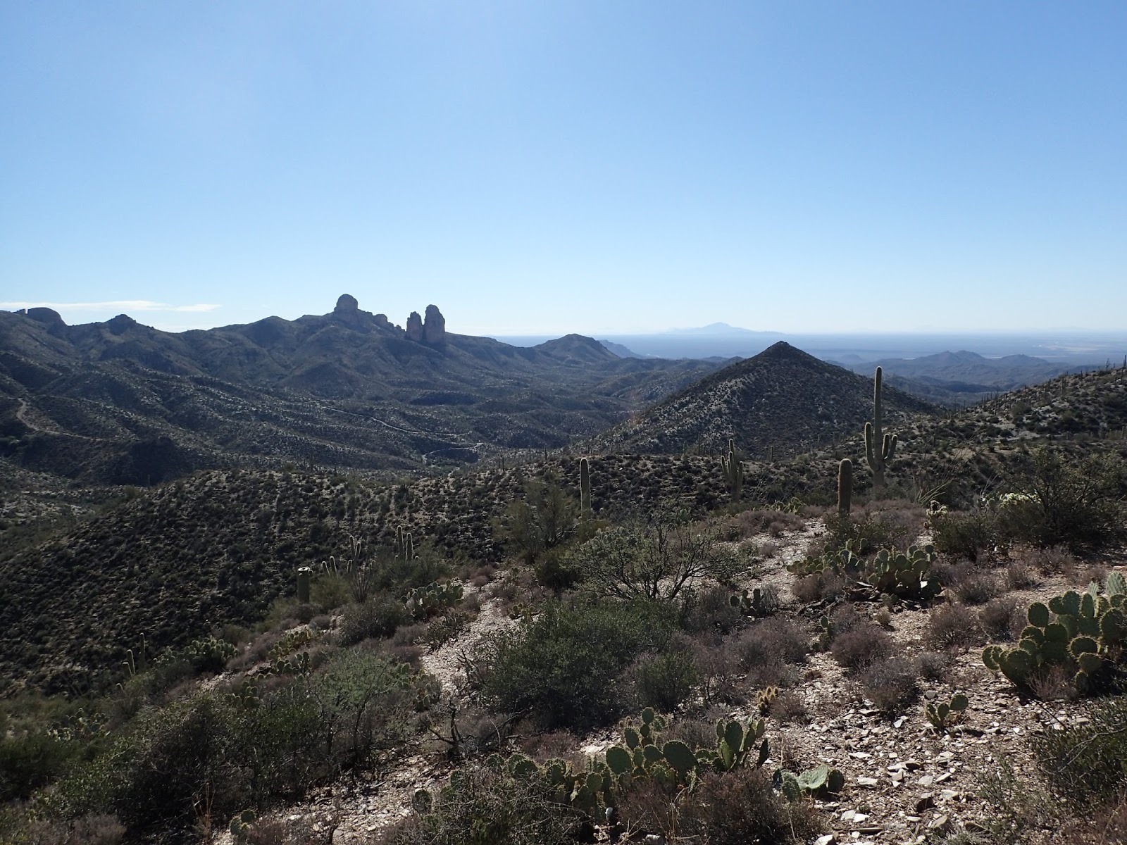
The AZT south of Picketpost trailhead is dominated by Picket Post mountain for a good long time. It just makes a great background for pictures.


As we plunked along, climbing the AZT, Craig Gregory came up behind us looking for John. Craig is trail steward for segment 18. He has led a lot of the improvements on Montana Mountain - which has been nice for the Punisher race. Anyhow, he and John had emailed for years, but never met. So we spent some time catching up.
A bit later Nancy noticed her front tire was low. We added some air and moved on. That didn't work for long, so we stopped to added sealant and air. It's a good thing we were not in a hurry today.

Scenic place to work on your bike.

yeah, he's having fun


Even little drops can be a more challenging with full gear
There is a section on this trail, before FR4 (Telegraph Canyon Road), that is a series of switchbacks up a hill. John has a thing about trying to clean these. Well, actually he has a thing about switchbacks everywhere. I've seen him risk his life just to clean some particularly sketchy ones. This, however, was not his day.

Got that one

Gotta love the desert scenery
We eventually made it to FR4, which was our turn off from the AZT. From there we'd take FR4 up and over to Ajax mine.

Joe is in there grinding out the climb

We encountered plenty of 4 wheelers out there

Made it to the top!. Not really - just a false summit.
The view to the south from the actual top. Mt. Lemon in the far distance

And down we go

A little sketch here

Hard to believe how quickly we descended from the right hand top corner
We rolled down to Ajax mine and started exploring. On our previous visit we had seen this cool looking structure on the hill, but did not have time to investigate. Today we were here to check it out. Turns out that structure is not actually the mine. The mine is just a hole in the ground. That big structure seems to be something for processing whatever they pulled out of the ground. At least that was our guess.

Yep, it is a hole in the ground

This looks like a house from a distance


View from the top
Back out on the road we rolled down toward Box Canyon.


More great views

And more of our 4 wheeled friends

Down into the canyon
We eventually made it down into the canyon proper. It is pretty sandy here, but we were rolling downhill, so made good progress.


The most often encountered critter in the AZ back country
A ways down the canyon is these remains of a house that was primarily constructed of mud. Can't imagine why someone build a residence in the bottom of a canyon. Seems like you'd be risking flood any time it rained.

Room with a view

The well was quite dry
On we went through the canyon.


After a bit it gets more narrow and dramatic. This is where we started seeing A LOT of 4 wheelers.


This is a really cool place to be

The canyon eventually ended and we were pretty close to the Gila river. My plan was to ride down to the railroad tracks that go along the river, ride along or on the tracks (where necessary), then through the train tunnel, and over the train bridge.That would get us very close to our camping spot for the night.
However, there was some spirited discussion about the legality/wisdom of taking the the train tunnel/bridge. In the end, Joe and Nancy headed down the road toward the dam that crossed the Gila a couple of miles down (in the wrong direction). John and I opted to continue down the wash to the river. We'd see if we could cross. If not, we'd go via railroad tracks.
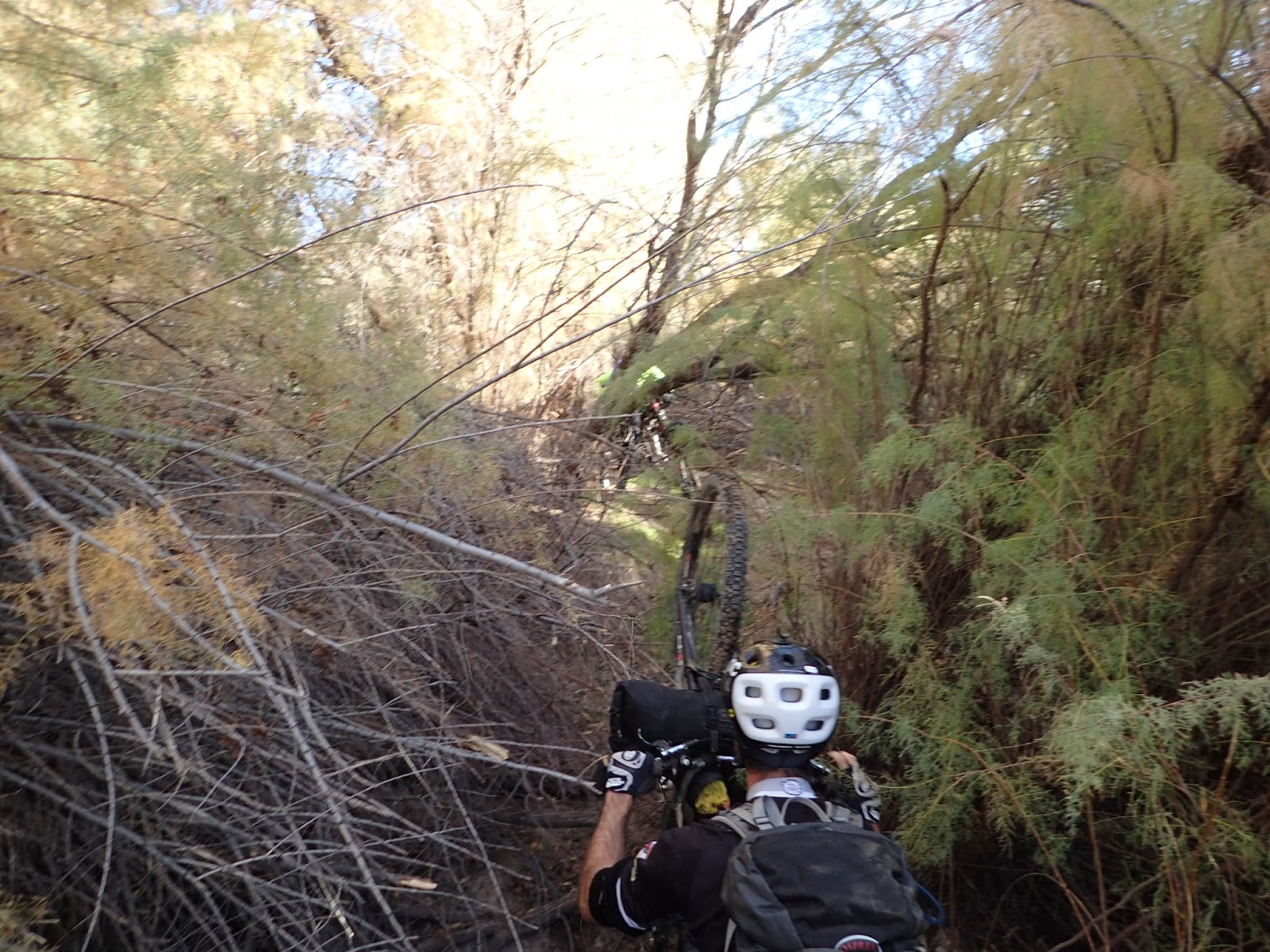
As we rolled down to, and under, the railroad tracks we followed 4 wheeler tracks. They obviously headed for the river - so there must be a crossing. When we got to the river, there was no obvious crossing, but we could see that the 4 wheeler had gone across to a sand bank on the other side. The river was super low so we took off our shoes and walked the bikes over. Here the four wheeler had turned around and gone back. Like him, we saw no obvious way through the trees on the other side. In order to get closer to scope it out we had to go up a muddy bank. So now our feet were covered in mud and the woods still looked pretty thick. Being no strangers to bushwhacking we decided to go for it. How bad could it be....
After scraping mud off our feet we started pushing our way through the brush. It was thicker than you'd think - especially for the desert. We eventually worked out a pattern. Bushwhack through a section without bikes, drop our packs, go back for the bikes, drag them to the packs, repeat. This worked pretty good except for the time when we went back to get the bikes and couldn't figure out where we left them. That took a few minutes of searching.


Thankfully, the brush thicket was not too wide and we eventually reached desert - and the road we wanted to be on. After about 5 minutes of riding on that we came upon Nancy and Joe. Despite taking the longer way, they were ahead of us. Perhaps Nancy was right...
On we went down a sandy, then rocky jeep road toward Area 52 - our destination for the night.

South Butte is right next to Area 52
We found a nice spot on a hill between Area 52 and South Butte for camp. Great views in every direction.

How can you not love being here

Great camp spot

Sunrise on South Butte

Breakfast time

More sand - down toward the Gila

This was actually a gate - but the top part would not come off.

The dreaded train tunnel and bridge

Ok, this is looking interesting
We found a passage to the river through the brush - no problem. Should be the same on the other side - right? Sure.

Once we got to the river it was time to filter water. Then we crossed and figured out how to get through the brush on the other side.


Shoes back on

Once out of the woods we rolled down more dirt roads to the area where the coke ovens are. These are visible from the other side of the river, but you don't really get an idea of how big they are until you are up close. Very cool.


Seen better days
Unfortunately, the "road" out of that area is a rocky mess. It gains about 300 feet in elevation, just to drop you back down to the river on the other side. So, lots of HAB going up and sketchy rocky going down. Fun.

Once we got over the "hump" and back down to the river, we were buzzed by a pair of black helicopters. They went down low on the other side of the river, then took off. Not sure what that was about.

Time to head back to the AZT where we had the classic climb out of the Gila between us and the end of the day.


tree tunnel
I pretty much stopped taking pictures when we hit the AZT because I have so many pics of that area already - plus was grinding out the big climb.
One item of note is a brand new gate. Much needed since the old one was falling apart. This is one of the new Rob Bauer gates - really nicely done.

Day two of this trip took a bit longer than I expected. The mileage was nearly the same as day one,but more climbing and just more challenging terrain. Regardless, it was a great route with all the classic ingredients - sunny skies, amazing scenery, great camping spot, gratuitous HAB, route finding, bushwhacking, and river fording. Can't ask for more than that.

