WARNING: For anyone actually thinking about doing this route, I encourage you to read through. There are things we encountered, which Nancy and I wish we had been aware of before hand. I rate this as a route for advanced backpackers. Doing it in 3 days allows you to camp near water, but is a bit grueling. Taking 2 days to get to the arch would be much more enjoyable.
Preamble
The Grand Canyon Royal Arch/South Bass loop has been on our list for some time now. But the remoteness of the South Bass trailhead and an other mitigating factors (read ahead) made us put this one off. Accessing trailhead for this hike requires a 30+ mile journey on dirt roads. Near the end it crosses Havasupai reservation for less than 2 miles. Unfortunately, access to that land has been denied by the tribe since Covid hit. While is still possible to drive to the gated border of the reservation, the National Park regulations required permit holders to hike the last 7 miles to the start of hike rather than drive across the reservation. Of course, there is no water or any type of facilities out there to make the approach even more complicated. So, we waited - figuring the Havasupai section would open up once Covid was less of an issue. Nope. A couple of years later and it turns out the current administration of the tribe still has no intention of opening access to that land at all. It became clear that if we wanted to hike this route it was time to figure out a way to get this done.
First order of business: This loop has a 20 foot cliff that we'd have to rappel down. This means carrying harnesses, ATC, webbing and 40 feet of rope to do the rappel. Never having done this before, Nancy and I took a class to learn how to properly set up the rappel, and do so without getting hurt. We figured that this way we'd be good to go if it was just the two of us completing the Royal Arch loops. Fortunately, we were able to convince my niece Aislinn (Ash) and her friend Allie to come along on the adventure. They both have done a bit of rock climbing and were confident in setting up the rappel. We had backpacked before with Ash, so she sorta knew what she was getting into - as much as any of us. Allie had done a rim to rim trip in the canyon.
Next: Figuring out how to get to the trailhead. There is actually another road that bypasses the reservation, but it is not on the Forest Service maps, therefore they do not consider it an official road. That means driving on it would be driving off road - which is expressly NOT permitted. Nancy is not much into the law breaking (or risking not being able to hike the Grand Canyon again), so we crossed that option off the list. After much communication with the Grand Canyon Backcountry Office it was clear that there was no "legal" way to drive to the trailhead. Instead we got creative and decided to park at the Havasupai gate and ride bikes to the rim the morning of our first day of hiking. What could possibly go wrong?
Day 1
We met Allie and Ash at the Yavapai lodge and spent the night before the hike indoors - which was nice as it was VERY cold and windy at the rim with rain in the forecast.
spirits are high
Allie had procured a nice big pickup truck which we piled all of our stuff and bikes in for the ride out to the trailhead. However, what Allie did not procure was the rope bag with her hiking boots and poles and some other stuff. Ash loaned her ski poles to help with hiking, but Allie was stuck with Teva sandals for footwear. I truly don't know how, but she did this entire loop in those Tevas. Anyhow, we started earlyish Friday morning - but not as early as we should have, in retrospect. The drive out was fine - some bumpy parts, but mostly standard forest service road stuff. After an hour our so we arrived at the gate to the Havasupai reservation. Parked the truck and started getting ready.
loading up at the Backcountry Office parking lot
none shall pass
I guess they are hauling water to the reservation?
Right off the bat, things got fun. I could talk about how Allie had to figure out how to lash the ski poles to her pack for the bike ride, but more importantly, the electric shifting on the bike she was using had a dead battery. So she had to do the ride in the highest gear - neato. Fortunately there were just a few steep climbs. The dirt path along the fence and then the road to the trailhead ascended pretty gradually most of the way, so Allie was able to ride most of it.
let's go!
ski poles hanging off and only the highest gear available + in Tevas - awkward
old ranger station
Once at the trailhead we, of course, saw a truck. Anyone parking there either illegally crossed the reservation or illegally drove off road. Whatevs. We found some trees to lock the bikes to and prepared to descend down South Bass trail - into the abyss. Right away we are pretty pleased with the tread of the trail. It was actually really nice - at least compared to a lot of the off corridor trails we've hiked.
bikes secured
nice camp spot at the trailhead
Ash is ready to do this
nice trail
minor impediment
One the way down we passed by what appeared to be ancient storage areas - very much like the granaries at the bottom of
Nankoweep. Down we went to the Esplanade level where we quickly came to the intersection that would close our loop 4 days later. The trail along the Esplanade was pretty easy going. This was going to be a breeze...
rather inconvenient cupboard
down on the esplanade
it was a rare cool, cloudy May day
somewhere out there is the canyon we are heading to
a little seep spring before Toltec Point
still feeling good
After a bit the trail turned more onto the side of hills rather than over flat ground, and got more rugged. Eventually we started to descend into the canyon where Royal Arch Creek was. This was actually a dry creek, but there were occasional pools of water.
trail getting a bit rockier
lunch time!
lunch is over, time to move on ahead
fun with rocks
little break before dropping in
heading down into the canyon
it was really nice seeing water out here
slide rock
watch out for that rock!
lots of cool pools
Our first big challenge, and one that had been well documented was a pour over that dropped 200 feet. There were two ways to get around - the "ledge of death" on the left and a different trail on the right. We decided against the ledge of death. Be that as it may, the trail on the right led us along the cliffside a bit then dropped down pretty quickly. One of the sections on the drop actually had me a bit nervous. It was a really tricky drop that we had to shed packs to do safely. I didn't even take pics there cause I was a bit wigged out. After that we made our way back down to the bed of the canyon.
the big drop off is to the left there
to the very right is the "ledge of death" - where there is barely any foot or hand hold
high above the canyon floor still
tight squeeze
the big pour off in the middle there
time to work our way down
that crease beside Ash was more challenging than it may appear
safely down to the bottom
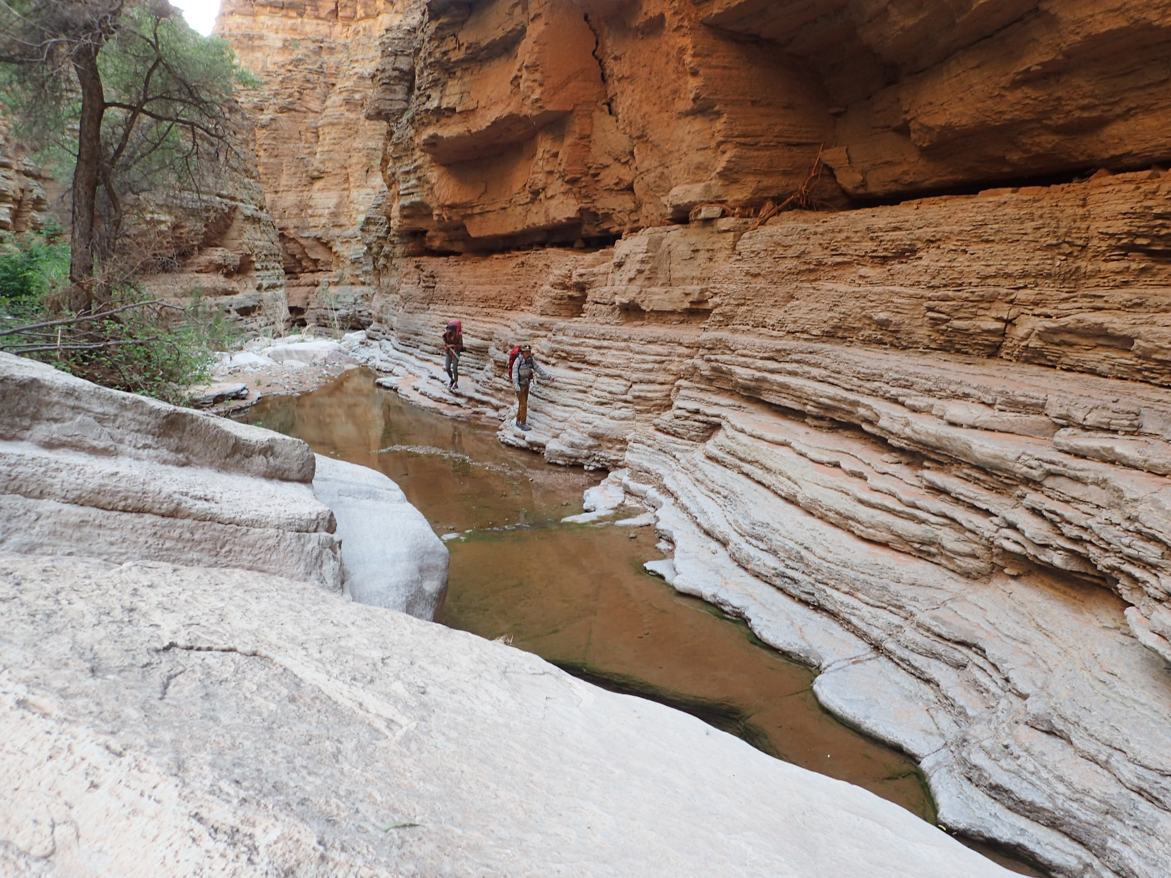
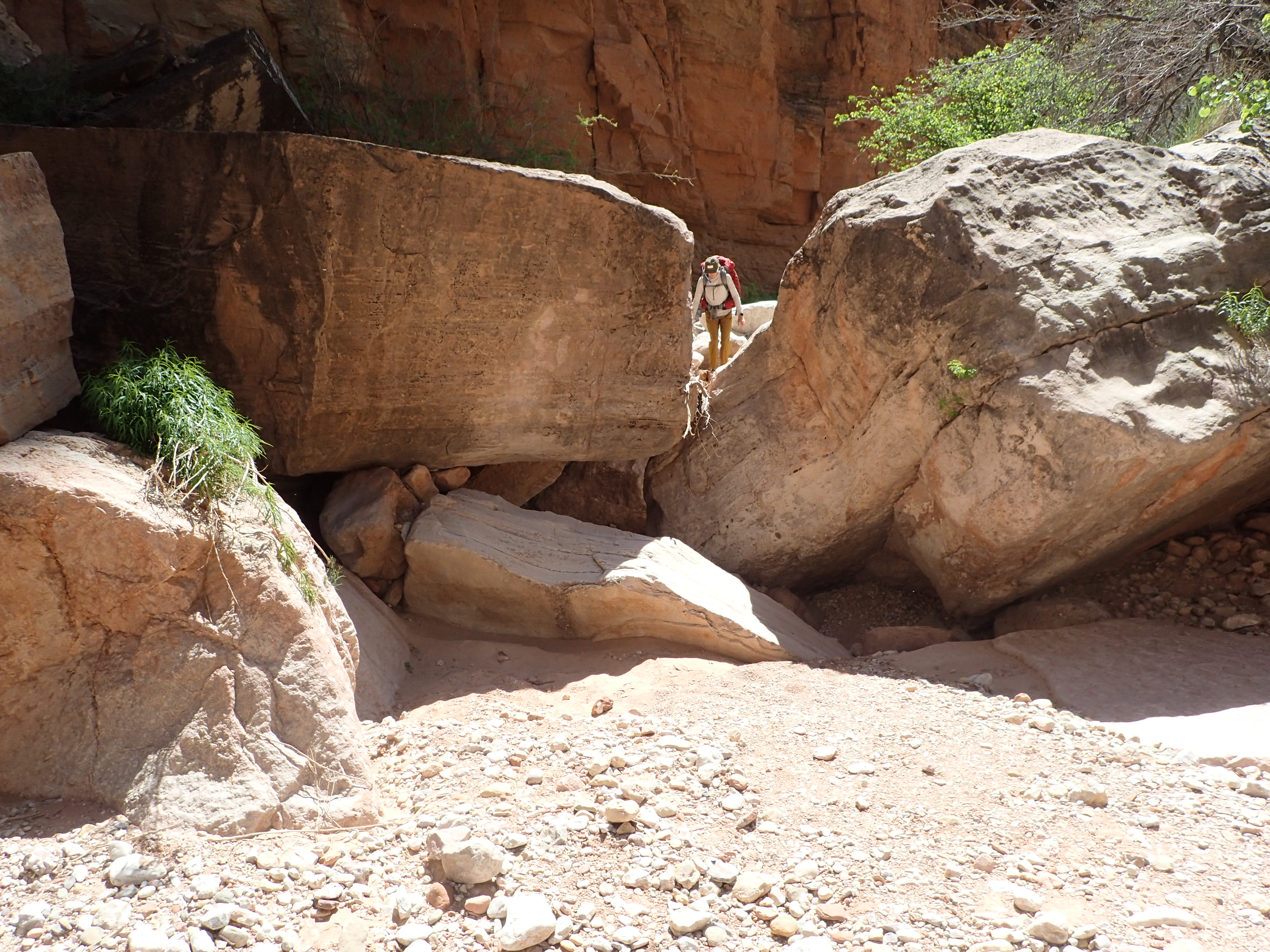
As the canyon got deeper and turned toward the north, it also got a little more challenging. Instead of just bopping along enjoying the scenery, we started having to work for forward progress. There were sections where huge boulders went across the canyon. Most of these were puzzles where we had to figure out if we could go around on the right, left or middle. The answer was different for each one. Certainly this really slowed us down and required some creative descending and occasional pack removal.
it was often like that
We were feeling pretty good about our ability to solve each one of these sections - then we came to the first pool. It was deep (over my head), long, very cold, and had no possible way to go around. We were able to go around on one side - to a point past the water, but the drop there was sheer and too far to go down. We had rope, but there was nothing to attach to for a rappel. So, we got creative. We decided to drop the packs down with the rope and we would swim across. The pack drop went fine. I was first in the water - and it was sooooo cold. Now this trip started on a day when a cold front had gone through and temps were nice for hiking - but not nice for being wet. We all got through the pool and started hiking real quick to get back some body heat.
sooooo, how to get across that?
swim through cccccold water
the rope came in handy
Then we came to the second pool. This one was similar in size, but had no way to go around at all. We could not drop packs. It was too deep to walk through with packs over our heads and we did not want all of our stuff to get soaked. So what to do? After some examination, we noticed there was sort of a ledge on one side - most of the way along. It was small, muddy and very little in the way of hand holds. So we'd try to cross that way with packs on our backs. I went first. It was slow going and my feet quickly turned numb from the cold water. I used what little hand holds I could find to keep from slipping into the pool. Through some miracle I made it to about 2 feet from the end - then fell in backwards. Since the pool had sloped up by that point I was able to stand a bit and threw my pack up on the bank. Then I attempted to scramble up out of the water, but the bank was sloped and muddy and could not find anything to grab to help me get out. Finally my feet found something to push against and I crawled up the bank and out of the water. I was soaked and sooooo cold. Major shivering commenced. After watching this fiasco, the gals thought the plan through a little more. We decided to tie the climbing rope to each person's pack as they went across. That way if they did fall in I could haul their pack out so that it didn't sink to the bottom of this pool. Also they could grab on and be pulled out. Nancy went next. We watched nervously as she picked her way across. She took a different route than I did, using some parts of the wall that were out of the water. As she neared the end we were all holding our breath. When she got to where I fell she took her pack off and I basically hauled it over to the dry area before it hit the water. She then carefully made it the rest of the way. Success! By this time I was shivering like crazy from cold and nerves. But we still had to get Allie and Ash across. Allie was next. She opted to go barefoot. Right from the start she had a lot of trouble trying to figure out how to proceed. There was a whole lot of trying different places to put her feet to find a stable place. Slowly she made progress and repeated what Nancy did. So two down, Ash was last. I could draw this out, but suffice it to say that she ALSO made it across dry. Awesome!

Nancy
Ash
It is hard to describe the joy and relief of getting through that. We were wet, cold, and flush with adrenaline - but felt like we had escaped something even worse (like having a pack sink into the pool). That was some class A adventuring. Time to move it along.
a rare easy going section


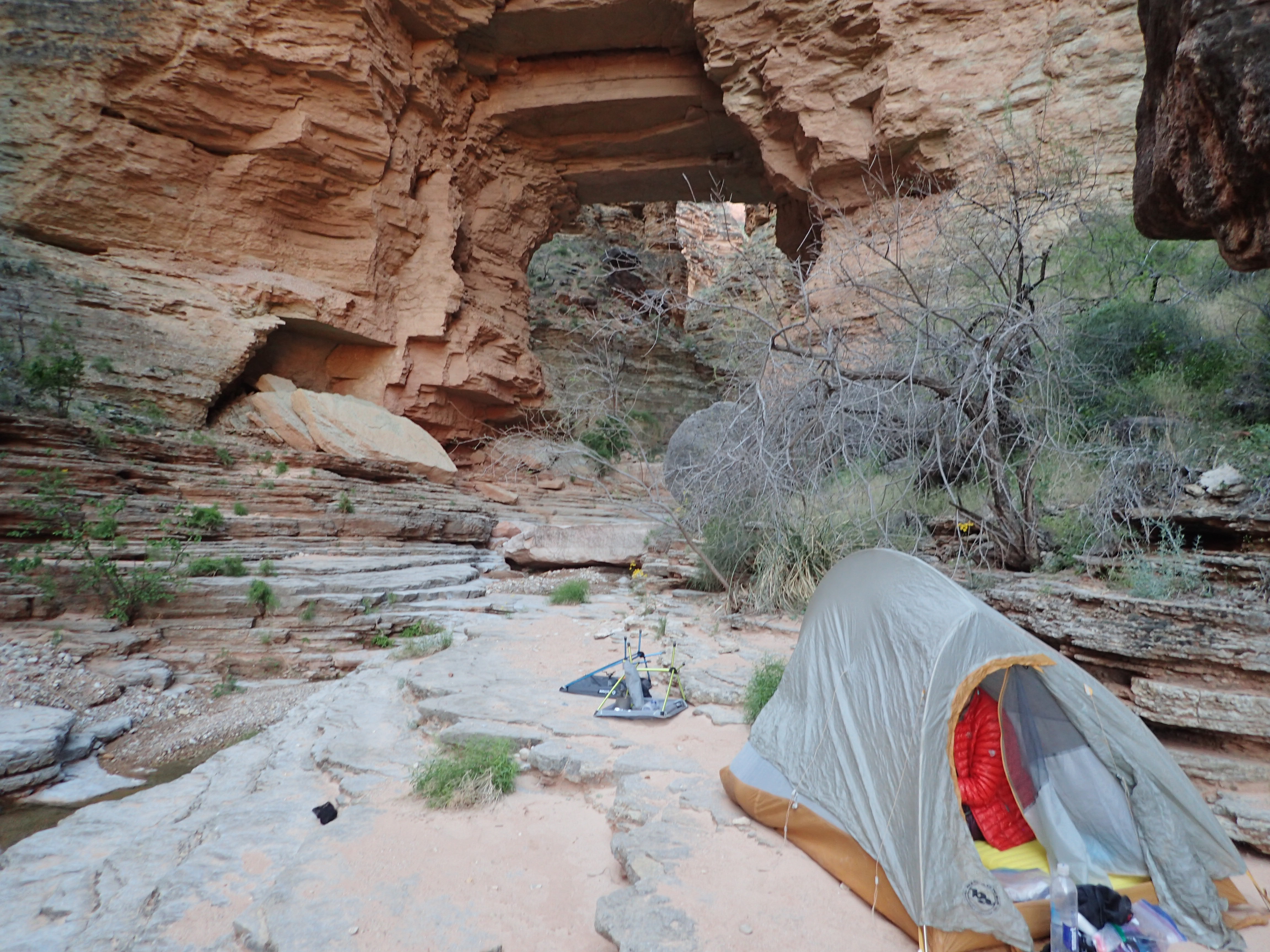
It was starting to get late. Our progress was much slower than I had expected due to all the challenges in this canyon We continued down, but still had to deal with the boulders blocking the canyon. We passed by a large cairn that appeared to mark the trail going out of the canyon. According to the Park Service description that was about .5 miles from the arch. Awesome. After a half mile I pulled out my GPS and noticed that we were not even to the point where the track showed the trail going out of the canyon. What the heck?? Maybe that cairn was a different path out? By this point we were emotionally and physically drained and just wanted to end the day. It was starting to get dusk and it looked like we had like another mile to go. I was getting really stressed cause I didn't want to hike that mess in the dark. Finally we saw a spring - which I knew was near the arch - but it was starting to get dark. I kept thinking that damned arch had to be near and it better be spectacular. Finally, we came around a corner and there it was. It was bigger than I expected, and yeah, it was spectacular. We did some brief scouting to find a place to spend the night before we lost the light completely. In the end, this was one of the coolest spots to camp at that I've experienced - and we have camped in some pretty amazing places. Ash and Allie camped feet from the edge of a 200 foot drop down toward the river. It was a breathtaking spot.

we've reached the spring, so not far now
The pics below are from the next morning - cause we arrived here pretty much in the dark
Royal Arch is actually a natural bridge - not an arch
we hoped this would stay standing one more day
what a great place to spend some time
big drop mere feet from Ash and Allie's tent
living on the edge
We ended up with almost 15 miles in 10 hours and 2600 feet of climbing - on a trail that went DOWN into the canyon - plus the 7 mile bike ride. Brutal. In retrospect, this section would be better done in two days - even with the complexity of dry camping.
Day 2
Day 2 was supposed to be our rest day. Only 3 miles to the river. We'd set up camp and hike without packs 1.5 miles downstream to Elves Chasm. Nancy and I had been there on a
river trip and remembered it to be well worth seeing. This day included a 20 foot rappel, but with both Ash and Allie having experience with climbing, I figured that would be no problem. Turns out that the rappel was the easiest, funnest part of the day.
After a leisurely morning to enjoy our surroundings we packed up and headed back up the canyon. The National Park Service description and my GPS showed the trail out to be about .5 miles away. Probably we just missed seeing it coming down cause it was getting dark. As we approached the point where the GPS track indicated we should go up, there was no sign of a trail. There was a little cairn, but when we went as far as we could up the side of the canyon it was obvious there was no way out there. Nancy said she had seen a cairn further back toward the arch. She investigated a bit and found what appeared to be a trail. We all headed back down there and clambered up that a while and went along a sketchy ledge to dead end. That clearly was not it. OK, so now what? At this point we had wasted a bunch of time and effort trying to find the trail out where it was supposed to be. My stress level was getting really high. If we couldn't get out of this damned canyon we might actually have to use the panic button on the Spot. There was no way I wanted to go back the way we came – it was so hard getting here – I just couldn't. We decided the best course was to go back to the big cairn we saw the night before and check it out. I thought it looked like an actual trail. That turned out to be more like a mile from the arch but it did actually go up the side of the canyon. It then ran along the edge (very close at times) and appeared to be our way out. Eventually the trail more or less coincided with the GPS track we had, so we had made it out. We think that the original trail must have been cut off by a rock fall and that they made this new one. Unfortunately the write up from the Park Service makes no mention of that. Very frustrating and stressful.

heading out to the beach
one of many sketchy sections we had to navigate
climbing out
and up
careful...
Royal Arch - top view
From here the trail was just fine. We had time to admire the flowers. One of the things that Ash was excited about for this trip was to see lots of desert flowers. I told her that wildflower season was essentially over so she may be disappointed. While that was true in the Sonoran Desert, it was far from true in the canyon. For those who want to see, there are a bunch of flower pics
here.
We were far above the river at this point and started to descend aggressively through some nasty, sharp volcanic rock. I expect this is where Nancy's ultra lightweight pack got huge rips in both side pockets. But I think all of our packs suffered to some degree. The descent led us to the section where we'd have to rappel down. Ash set up the rope and Allie was first one down. Ash lowered packs to her and then I, Nancy, and Ash followed. This was only 20 feet, but it was fun.
taking a break before the rappel
Ash and Allie sorting out the ropes
Allie was first down
After this there were more sketchy drops through the volcanic rock. Then the trail descended pretty steeply toward the beach. When we finally reached the beach we were surprised to find it was late afternoon. The "3 mile hike" turned into 7 miles according to my GPS - which certainly could be off given the challenge of finding satellites in the canyon. Regardless, this section did take us 5 hours, with 3800 feet of climbing.
this stuff was scarier than the rappel (notice the footwear)
the beach is just down there
coming down the hill
Nancy skiing down the sandy hill
good to be home - for the night
another excellent camp spot
At this point my feet were in a bad way and I had had enough of our "easy" day. Ash and Allie decided to go down to Elves Chasm - cause they had come this far and it would be criminal not to. Nancy and I had seen and enjoyed that waterfall, so we were good with staying at camp.
While the girls were off playing at the waterfall, Nancy patched up and sewed the slashes in her pack - which held up the rest of the trip.
is there any better place to be? yes, those are chairs. 1 lb. each and absolutely worth carrying
it ain't art, but it worked
burritos with rice and sprouts - yummy
GPS track gone wild. Our path was not this crazy, but it sure seemed that way at times
Day 3
We knew this would be a long, dry, warm day so we filled up on water. We started out early on a "trail" along the river.
it was mostly like this before we got on the Tonto trail - VERY sharp lava rocks
thataway
Once we hit Garnet Canyon the trail went up to the layer were the Tonto trail is. This was actually the western terminus of the Tonto Trail. The trail quality got much better here. However, the way the Tonto trail is laid out it goes in and out of drainages. So 1 mile of river can be equal to 2 miles of trail.
cool little lagoon down there
climbing up to Tonto
hello there little guy
The Tonto trail runs 95 miles along a "middle" layer of the Grand Canyon. It is round about 1000 feet above the river for most of it's length, and there are very few creeks that you can safely drink from crossing it. So getting water usually means you have to take a trail down to the river and back. It is a good option for doing loops - like the one we are doing. The tread of the trail is mostly pretty good, but there are always rocks to navigate when you cross drainages.
Tonto trail
this trail offers some really great views
So, lots of miles with flowers and spectacular views of the canyon and river. As we neared Bass Canyon there were two ways to go. The main trail sent you up the canyon a little than dropped into the canyon. This is the appropriate route for someone heading back up to the rim. There was, however, a shortcut that headed toward the river. This is what I had on the GPS track. However, as the Tonto trail went on and on Nancy and I pulled ahead of Ash and Allie (at this point Ash was having problems with the foot she had injured last year). Unfortunately I was so focused on getting to Bass Beach that I didn't think about how far apart we were. I completely missed the turnoff for the shortcut so kept going on the main trail toward the higher part of Bass Canyon. Unfortunately Ash and Allie saw the cairn for the shortcut but were not sure if we had taken it or not. They did some investigation of the trail, but decided that if we went that way we would have waited for them - which was the correct take. So they decided to continue on the main trail. This was a big mistake on Nancy and my part. We should never have let them get out of sight. Fortunately it worked out. Unfortunately, the route we ended up taking was 2 miles longer than the shortcut. So a long day was even longer than it needed to be.
We finally hit Bass Canyon and headed the 2 miles down to the beach. Ash's foot was REALLY starting to bother her at this point and the pace went way down. So close, but not there. Nancy and I decided we haul down to the beach, drop packs, get some water, hike back to Ash and Allie and carry Ash's pack down to the river. However, as we ventured down the trail we missed ANOTHER shortcut to Bass beach and ended up going down river on a random trail for another 1/4 mile. We finally got our act together and figured out how to get to the beach. We filtered some water and decided that Nancy would go back since she was the least damaged (I had blisters on my feet). However, Ash had somewhat recovered and while we were messing around on the wrong trail she and Allie made their way down the correct trail. Nancy ran into them just as they hit the beach - so she carried Ash's pack about 200 feet. A short assist but good intentions.
When we got to the beach there was a group of guys already here, but we found our own section of the beach. These were the first people we had seen on the entire trip - which we all considered a good thing. We pumped Ash with Ibuprophen and she taped up her ankle best she could, along with soaking it in the VERY cold river. We hoped this would be good enough for the next day = which was a 7.5 mile climb out - plus the 7 mile bike ride back to the car.
We spent a very pleasant night on the beach.
chill time
The day ended up 17 miles even though the description and track I had said it was only about 12. Two of those extra miles were my fault, but not sure where the other 3 came from. Needless to say we were all pretty wiped out.
Day 4
The description and the track I had said this was a 7.5 mile hike with about 4400 feet of elevation gain. Compared to the 1st and 3rd day it should be a breeze. But then we didn't know what the trail would be like. Many of the off corridor trails we've been on have been really raw. But this one started out pretty nice.
The other group of guys that camped at this beach were up and out before us - even though we had planned to leave by 6ish.
The first two miles of the trail were good - but we knew what to expect, having hiked down that the previous day. As we ascended beyond the intersection with Tonto the trail tread continued to be pretty nice. Sure there were occasional patches of heavy vegetation, but all in all the trail was nearly as good as the main corridor.
a little bit of rock climbing to start the day
this little fireplace marks the shortcut to the beach - that we missed
looking back to the river
parts of this could have used some trimming
As the day got warmer, we got higher in elevation, so it didn't get too hot. Took a nice break in the shade.
making progress
starting to get more rocky, which means we are close to the top of this section
the river is wayyyy down there
Then onward and upward. Finally we topped out onto the Esplanade, which was a huge achievement. We still had plenty of climbing to do, but this was a nice psychological boost. We walked along Esplanade on easy trail for a while, then came to the intersection we had been at 4 days earlier. Even bigger boost cause we knew exactly what was ahead. Unfortunately my camera battery died at about this point, so no more pics on the way up.
yay! over the first level onto the flats of the esplanade
fancy trail
closed the loop. from here it was a repeat of trail we did 4 days before - except up this time
There was a little bit of technical stuff but, really, the trail was nice overall. We eventually ground out the final bit and reached the top. Unfortunately I didn't get a picture of Ash hugging the sign at the top - but we all felt it.
We retrieved the bikes and motored the 7 miles back to the car. Fortunately it was "mostly" downhill at this point so the going was pretty easy. I've never been so happy to see a pickup truck before.
time to ride back to the car!
30+ miles of dirt roads back. (thank you Allie for driving) and we went to Maswik food court to get some huge burritos - which Nancy and I had promised Ash when we were down at the bottom. Imagine my disappointment when they no longer had burritos on the menu. Taco salad - no thank you. I got barbecue instead. Ash and Nancy did better. The dining manager overheard them asking the servers for burritos and volunteered to specially make them a couple of huge burritos. So, promise kept. We gorged ourselves, headed back to the cars and went our separate ways - knowing that none of us would ever forget this adventure.
I realized later that my GPS battery had also died pretty close to camp that last day, so I don't have a real track for it - just what I found on line.
This was easily the toughest backpacking trip any of us had done. It surely could have been made easier by adding extra days, but the large stretches with no water source make that a bit difficult to do. This loop pushed us to our limits, but we worked together to get through the various obstacles. In spite of the challenges we were all happy to have had the opportunity to experience this route. It was an outstanding adventure in amazingly beautiful places that few get to see. I'll gladly go on some other crazy adventure with those 3 amazing women any time. But for now I just need to rest my feet a while.