New Adventure = New Stuff or New Stuff = New Adventure?
After 13 years of using the same bikepacking gear I decided it was time to look into the many, many new choices out there. Most of my original stuff was Revelate, cause they were the big dogs in that space back then. However, upon reviewing the current deluge of offerings, and checking out some gear Nancy is using, I went mostly with Rogue Panda gear. Bonus that they are local - Flagstaff. I did get one under downtube back from Revelate and some swanky fork mount adapters from Tailfin. The two Revelate bags on the top tube are quite old, but still useful.
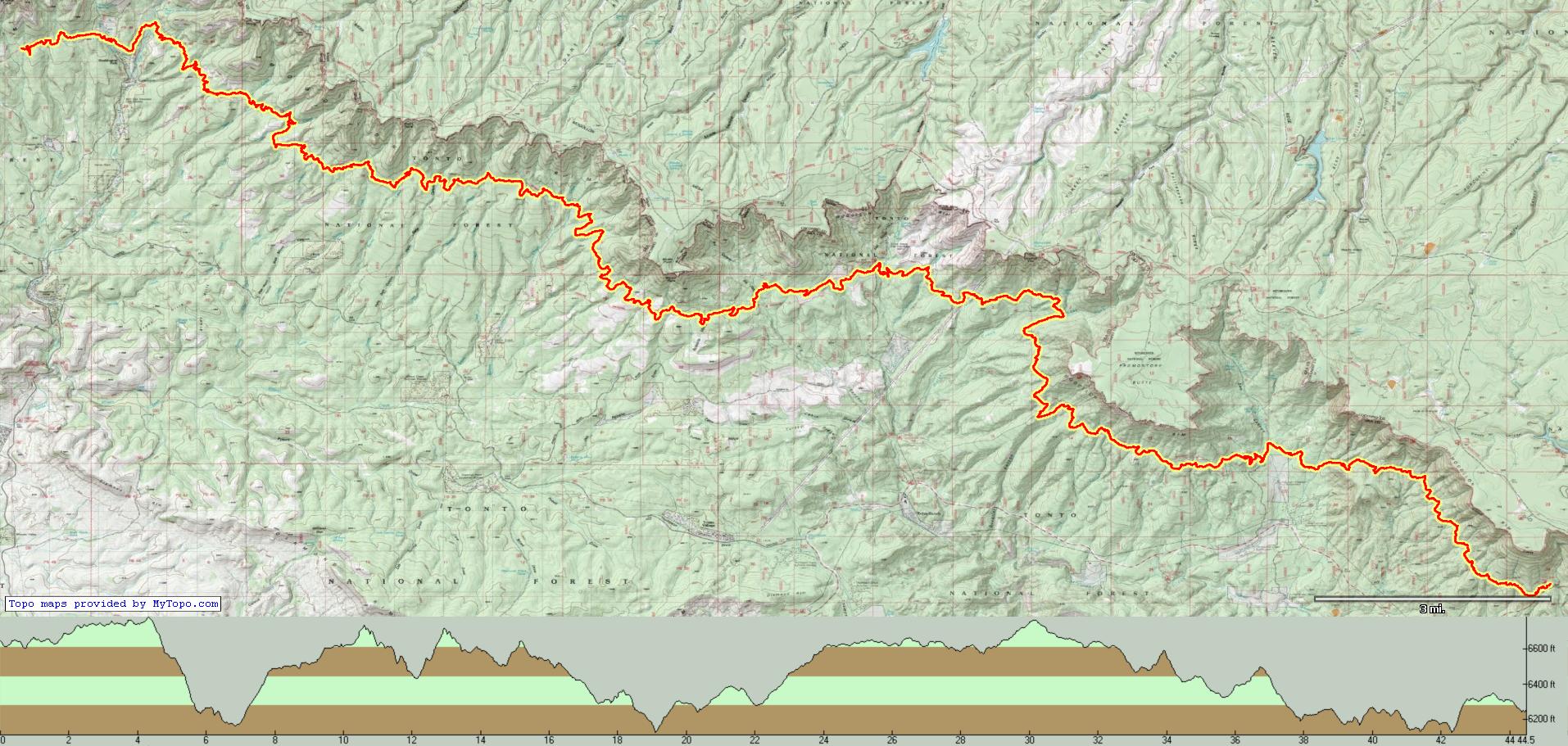
So now I got the gear - I just needed to test it all out. The Highline trail, up below the Mogollon Rim was once a disaster on bikes. The fact that the Arizona Trail used part of it to get from Pine to the top of the rim made that one of the dreaded sections of the AZT 750 (now 800). However, there has been a ton of work on the entire trail in the last few years, and it is very much improved. I floated the idea to Nancy to spend some quality time riding the entire trail - with a return utilizing dirt roads and a little of the trail, for a 107-mile loop. Of course she was in. I expected it to take 2 long days and one short.
Day 1
Geared up and ready to roll.
Turns out I needed to secure the fork mounted water bottles with a strap. I'd lose one in the first couple of hours of the ride.
Nice trails right off the bat
It is a nice change for us desert folk to ride in the woods
Getting into the red rocks
There were some rocky sections in the first part of day one, but easy to forget when the trail smoothed out and went down.
Lots of ferns out now
Little Sedona
Big views up here. The first 50ish miles contours right below the cliffs of the rim.
It ain't a real ride without some hike-a-bike
..

But then you get this.
The trail is overall really scenic.
Nice job benching that trail in.
Horton Springs. Reliable water source.
More ferns.
See all those rocks? Not on the trail. At least not here...
Flowing water is always a beautiful thing in AZ.
Lots of Sedonish rock on this trail.
Terrific views.
This area used to be covered in Manzanita, but they chipped most of the vegetation to make it a fire break. Even up here fire is an issue.
Yes, I was actually also on this ride.
Assume the position.
Some really nice creeks up here.
These gates are a big improvement from the barbed wire and stick ones that used to be there.
This was a really nice little valley.
Careful...
My original plan had us getting to Washington Park (41miles) with a stretch goal to Geronimo (52 miles) or one of the spots I knew had reliable water before Geronimo. However, by the time we got to Washington Park it was starting to get late, and we were starting to get cooked. The pace was slower than I expected. We decided to fill up with water at the Verde and continue on until we found a decent place to call it a night.
Gravity filtering - FTW
As we moved on from Washington Park there was a nice stout climb, and the trail was either lined with Manzanita or on a pretty aggressive slope. Nancy kept telling me we'd find an amazing spot by 6:30. Not that I'd ever doubt her, but it didn't look very good. Even where there were wooded areas that looked promising, there were so many downed trees there was nowhere to put a tent. And then, about 3 miles out of Washington Park we came upon one of the red rock sections - which just happened to have a perfect place to camp.
Yeah, that will do.
Sadly, the campfire ring was no go - open fires not allowed due to dry conditions.
I'm really not checking my phone - no cell service here.
But it works to time how long my Bison Chili took to rehydrate.
View from camp.
Day 1 ended with 44.5 miles and 4100 feet of climbing, over 10 hours.
Day 2
At this point we were behind where I had hoped to be. The trail was just a bit slower going than I thought it would be. Given our lack of progress, we discussed "options" but decided to stay the course - complete with a side trip to Pine for some quality calorie loading.
Off we go
Great views of the rim
Nancy hitting a little rock incline.
Just look at that. So cool to be out here.
Once we passed Washington Park we were on the section of Highline that overlaps the Arizona Trail.
Unfortunately, there were a few burn sections.
Desolate.
After Geronimo, it felt like we were constantly climbing. And we pretty much were - for about 7 miles straight. But then, the big 3-mile descent to the finish at the Pine trailhead.
Down we go - finally.
Completed all 62 miles of the Highline trail!
And now it was time for a little trip into Pine. Since it was around 10:15 That Brewery was not yet open. Next alternative was Early Bird Cafe - which is where I stopped on the
750. It did not disappoint.
Yeah, I ate every bit of that. And burned it off in the next few hours

From the cafe we had a little over 2 miles on pavement to get to the dirt Control Road. This was the most unpleasant part of the trip. The drivers hauling UTVs and campers and stuff were not pleased to see bikes on the road. Lots of horns. Yeesh.
Anyhow, the rest of the day would be a series of dirt roads - mostly going up - to get us to our camp for the night. Not a lot of pics - cause dirt roads. There was little shade, and it was getting pretty warm out there. This ended up being a pretty tough stretch.
And here we go.
There was some downhill.
This was way rockier than it appears.
Camp for the night
We had considered it to be really lucky that we were able to reserve a spot in this campground for the night. It only has 6 spots and we knew it was nice and peaceful since we had stayed there before. Such luxuries as potable water, picnic table and pit toilets only added to the experience.
However, there was a big group at one of the sites that was playing music as we rolled in. Not really the experience that we, and I suspect most of the other campers, were looking for. As it started to get dark the music level went up to really obnoxious levels. I honestly don't understand that level of selfishness. Since no one else was going to do it, I went to the camp host and asked him to handle that. Soon the music went off and the peacefulness we were looking for returned.
Nancy did a quick watercolor of our view. She actually carries a little kit with her.
The day ended with 49 miles, 5000 feet of climbing over almost 9 hours.
Day 3
The final stretch back to the car was only 15 miles. How hard could it be?
Unfortunately, the first 3 miles were on the Derick Trail. It was very steep in spots and littered with rocks. There was a LOT of hike-a-bike on this section.
Pictures don't do it justice.
Coming up to the top.
Most of those rocks were on the trail lower down.
Back to highline.
More burn areas. Hate to see that.
Highline definitely flowed better in the other direction.
Finally, some nice trail.
A nice stream crossing before some VERY stout climbing - and more pushing.
Nancy's favorite flower - Columbine. In Arizona these are yellow.
Feels good to be done.
15 miles, 2200 feet of climbing over almost 4 hours.
Total for the trip 108 miles, 11,000 feet of climbing.
This was a really great trip. The trail was mostly very good and the scenery was excellent. I believe that with a shuttle, you could do the trail end to end in one day - starting at sunrise, with unloaded bikes and no messing around. However, doing it bikepacking style is much more enjoyable and gives you time to savor the trail.
New gear I was trying out:
Rogue Panda
Blue Ridge Harness and Accessory Bar - Total winners. Kept my front roll from rubbing on the bike or interfering with cables. Never slipped - even when rolling chunky stuff. Wish I had had this years ago.
Rogue Panda
Ripsey Seat Bag - I really like the fact that my rear tire never rubbed the bag. Although it wouldn't matter much since there is that plastic plate on the bottom to protect it. Liked the ability to easily remove the bag. The cinching isn't as dialed in as I'd like - takes a little getting used to. But happy with this as well.
Rogue Panda
custom fit frame bag - Nice bit of kit. I got a standard design, but you can get your own on the bag. Also, I got the bolt attachment, which is super nice. That way you don't need as many straps rubbing on the frame - but it is a PITA to install.
Tailfin
fork mounts - These worked excellently. Never slipped. Only issue was me not realizing that you need to add a strap to keep a water bottle from exiting its cage - that's my bad. These are pretty fiddly to put together and get sorted on the fork - but solid once they are there. One issue - I cracked the carbon on one of them when removing from the fork. I'm hoping Tailfin will make that right.
Revelate
Joey downtube bag - Super solid. Never slipped. Did rub on the tire a couple of times - I think I just need to move it down further. This was a nice place to put tools and other heavier stuff.