Nancy and I are on a quest to hike all the named trails in the Grand Canyon. The most recent is Nankoweap. Lots of information about this trail is available online. The one thing all these accounts have in common is the assertion that this is the "most difficult" of the named trails. I am usually skeptical of such claims, but in our experience, this seems true - but I'd also add that this is the most risky trail we've hiked.
Our good friend (Martin) from Pennsylvania came out for this. I enticed him with a promise to do the Royal Arch loop, but had to change plans due to closure of access to the trailhead for that loop because it crossed Native American lands. We'll do that one at a later date. However, I did keep Martin's interest by telling him that this had some crazy exposure.
I did a little bit of video for this. It turned out to be challenging to shoot video while hiking (as you will see) so I only shot a little bit.
Day 0
There are two ways to access Nankoweap. We opted to start at the western entry near the entrance to Grand Canyon National Park - Saddle Mountain trailhead. This offers a more scenic route than the northern access, but also adds 1500 feet of climbing at the end. Of course we had to do the harder/more scenic option.
We drove up to the north rim on the day that the road from Jacob Lake to the North Rim (and our trailhead) opened - May 15. Fortunately the forest service folks had done some work on the dirt road to the Saddle Mountain trailhead. There were a bunch of trees across the road - which they had cut a pathway through. We made it past all that and found a place to set up our tent for the night, right on the rim. It turned out that a lunar eclipse was supposed to happen that night, so there was more than the usual number of people at the trailhead. However, we had a killer view from our campsite.

One of many trees across Arizona FS610.

Our home with a view at Saddle Mountain trailhead.


Digging the view!

We head out along the rim tomorrow...

but tonight we feast.

Start of the eclipse.

Checking out the eclipse from a ridiculously scenic viewpoint.
Day 1
Time to get to it! The first part of this would be a hike along the rim to a saddle where we would begin the official Nankoweap Trail. On the way out this meant about 1300 feet of descending.
Let's do it!


Into the wilderness.

Of course there was climbing. Aren't we supposed to be going down?

The trail was pretty nice in spots.

One of the rare "flat-ish" sections of the trip.

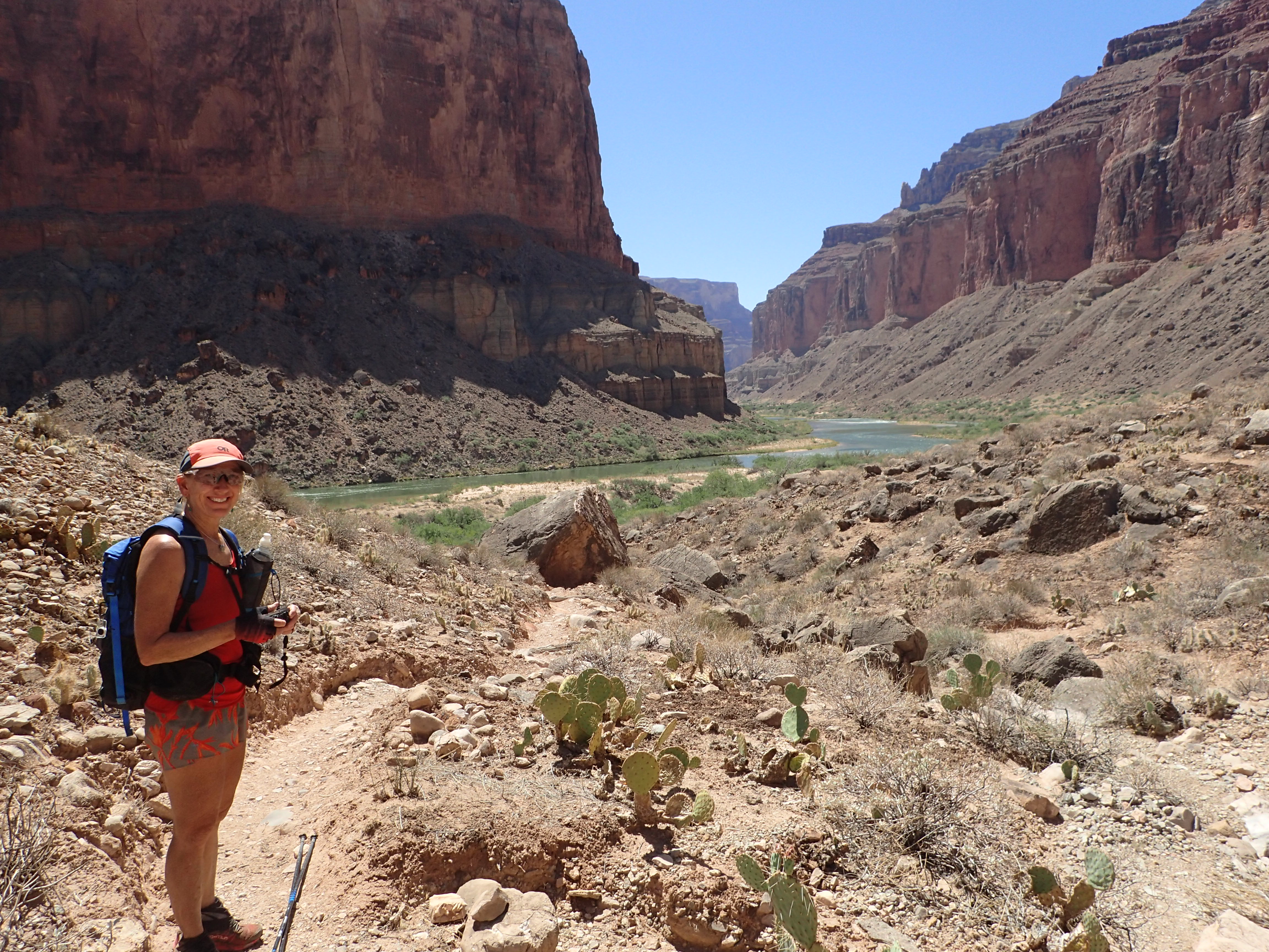
Marble Canyon in the distance. We are heading down, to the Grand Canyon around to the right.


Trail conditions were loose and dusty, with occasional downed tree crossings.

As we got close to dropping off the rim it started to look like Sedona. Red dirt!


Once we drop off the rim we enter Grand Canyon National Park.
After the hike along the rim, we reached the start of the Nankoweap trail. This "trail" drops down from the rim a bit, contours along for a long time then eventually drops down to Nankoweap Creek. Sounds simple, right?
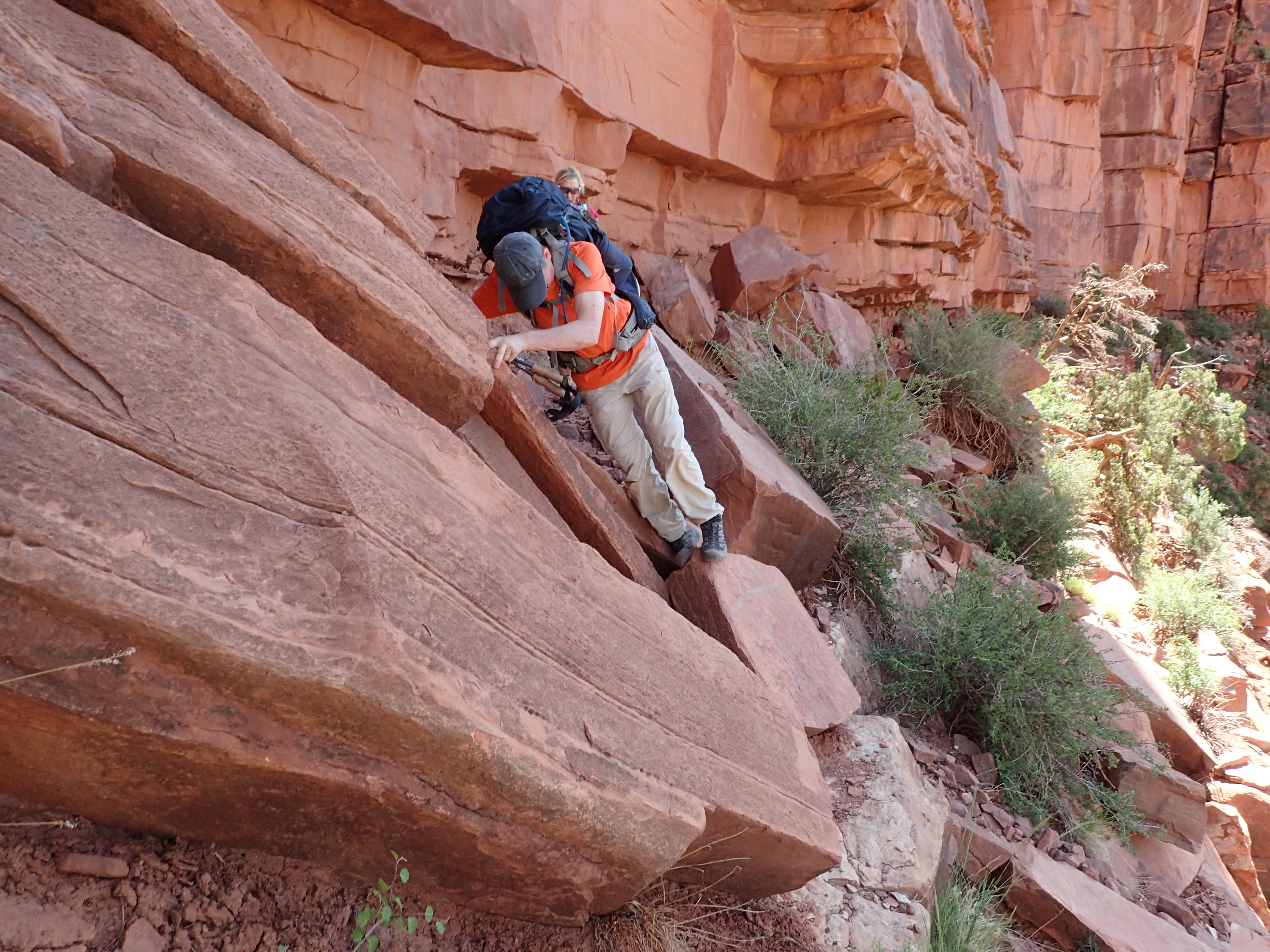
The first part of this was from the rim of the canyon to Tilted Mesa. That was about 5 miles of trail that contoured along cliffs. It dropped gradually, but not enough where you noticed it. What you did notice was the big drops to your right. Many descriptions of this section talk about this one "dangerous" section where you can fall down a cliff if you stumble off the trail. We never really figured out where that was because there were SO MANY places where a misstep would be very bad. The goal here was to focus on the trail and don't look down.

The trail starts to get real.


Dropping down off the saddle.

Lots o' rocks!

Heading down the the contour trail that we'd do about 5 miles on.

Marion Point in the distance.

We hiked below some massive cliffs.

Just one of the occasional rock falls to be negotiated.

Just one of the of many "scary" sections to be negotiated.

There is a trail there - somewhere. Can you find it?

A nice smooth section.

Stay focused.


That big rock sticking out is Marion Point.

A couple of miles in we reach Marion Point. There is a small, flat section there where a couple of people could dry camp. Our goal was the creek, so we just noted this section and moved on.

This was just past Marion Point.

We are headed to the very end of that point.


Looking back at Marion Point. We went to the right of those little spires.
The most intimidating part of the hike was a section where a couple of rocks jutted out over the trail. On the way down it was so much more scary because you could see that there was a huge drop on your right and it would be easy to slide down over that if you bumped the rock. Interestingly, this didn't seem so bad on the way back out - probably because we were looking up, not into the abyss.

Easy does it...

Some nice, easy trail. But not for long...


Yeah, that is the trail.

Almost to Tilted Mesa!

Time to drop off Tilted Mesa.

A challenge to start.

And some more rocks. Surprised?

And one more rock drop.

A little, well protected, camp spot on Tilted Mesa. Testament to the winds that can rage here.

Now for more "fun."

Yes, that is the trail.

Nankoweap Creek is the thin line of green down there.

Just loose rocks. Ugh.

"Hum. how do I get down here without falling?"

The creek is a little closer.

A little bit of nice trail.


More garbage trail.

Finally off the climb with a only a hike across a relatively flat area to go.

Just think...we hiked along those cliffs up there early in the day.

Finally to our home for the night.

Looking up Nankoweap Creek...

...and down the creek. OK, the Nankoweap flood plain. Not much is creek.

Our little slice of life giving water.

Dinner time!
Day 2
One of the goals of this hike was to visit the Nankoweap Granaries at the Colorado River. This required a 3 mile hike down Nankoweap Creek to the river. We decided to keep camp at the creek and down-and-back to the ancient Native American site. Nankoweap Creek is quite wide, but the creek is only a small rivulet during most of the year. It seems clear that there are regular and very powerful flash floods down this creek. This makes it very difficult to have any sort of trail so you just rock hop down it.

"Is there a trail here somewhere?"

The Colorado is supposed to be down there...


Finally out of the creek and heading up to the granaries. Operative word being UP.

It's an even bigger climb up to those cliffs.

Can you see the little window in the rock up there?

Unfortunately, a raft trip arrived at the same time we did. It was somewhat disconcerting to be on such an exposed trail with so many people.

Looking back down.

Really nice view down river.


Not much room inside.


Looking up river.


Behind Nancy is the beach where raft trips stop.
It was pretty warm, so we headed down to an unoccupied beach on the river. It was really nice, but the water was still very cold.

Time for a dunk in the water!


Still life on the beach.
Time to head back up to camp.

Not a lot of water in this creek, but still some nice features.


One of the springs feeding the creek.

A deer visited us a number of times while there and adopted Martin.

Siesta in the shade
Day 3
It was time to head out from the creek. Early! Up at 4:15 AM - started hiking at 5 AM! And it was light! Hot AZ summer adventuring = very early mornings.
Our goal was to get past the exposed cliffs and to the Saddle Mountain/Nankoweap Trail intersection This would afford us a relatively short final day. However, knowing how tough the trail is, we were not sure about how far we'd get. Good thing we had cached water at Tilted Mesa. This gave us the option to "dry camp" (a camp with no water source) there - or even at Marion Point - if necessary.

Catching my breath after some initial steep trail.


Climbing over rocks.

Watch your step!

We gained a lot of elevation quickly.

One of the "interesting" climbs up to Tilted Mesa.


Coming up over the worst of the climbing sections.

Just a little more fun before we get to the mesa.


Breakfast of Champions on Tilted Mesa
We made better time going up the climb to Tilted Mesa than going down. So that was good. After cooking up some breakfast and getting a little rest, we headed back to the trail.


Almost to Marion Point.


Break time at the little camping area at Marion Point. It is only just past 10 so we move on.
Back to navigating rocks.

Careful!

Nancy: "Yeah, no problem."


Again with the rock fall.


Low branch!

Finally! Final climb back to the saddle where the Nankoweap Trail began.


We made it!


Martin was first one to whip out his cell phone. Just sayin...


Nice little spot on the edge of the Grand Canyon.


Martin's bivy.
Day 4

Thursday morning. Time to wrap this up.


Let's go!

Lots of climbing. 1300 feet worth in 2.25 miles!

DONE!

The Three Amigos. Smiles mean: "Good to be done. Good to be alive!"
Extras

Day 1 - 10 miles, 6000 feet of descent

Day 2 - 7 miles, 1500 feet of climbing

Day 3 - 7 miles, 4300 feet of climbing

Day 4 - 2.25 miles, 1500 feet of climbing