Prelude
Nancy and I have done a number of hikes in the Grand Canyon main corridor, and even one off corridor hike (New Hance/Grandview loop with Chad), but we had not really explored the west end of the park. We had done a short hike down to Santa Maria springs with Ray and Britt, but that just whetted my appetite. I've been talking about doing a big loop of Hermit/Boucher for a while. Nancy has always been a little hesitant since Boucher has a (well deserved) reputation. It is not really maintained any more and is probably the most rugged trail on the south rim - even more than New Hance.For some reason at the end of summer I lost my mind and decided to do the bike ride from Shultz to the inner basin (not so hard) and continue on to hike up to the top of Mt. Humphreys. A couple of my friends had done this combo adventure and it was recommended. The hike was about 10 miles round trip and i would rate it as strenuous and Nancy as super-strenuous (first time I've seen her suffer on a hike). From that I got the idea of parleying this hike into the Hermit/Boucher hike i've been wanting to do. We spent the next two weekends trying to get me into hiking shape. While Nancy is a runner, I prefer to bike, so hiking is not easy for me. I needed to get in shape for this beast. We tried to arrange this hike with our hiking pal Chad, but that didn't work out. So it was just Nancy and I. Permits secured, date set, ready to go.
Day 1
We got a room at one the South Rim lodges to make an early start easy. It was pretty chilly up there. Our permit came with a gate code that allowed us to do the 10 mile drive to Hermit's rest - no waiting for the bus. We grabbed our gear out of the car and i realized that i had brought mismatched hiking poles. We had some inexpensive poles that our friend Martin had left when he did the Paria hike with us. No problem, poles are poles. I stared getting set up and found that I had grabbed two different poles and one I couldn't get to lock. This was a problem.Side note:
I used to think hiking poles were for old people. After seeing some friends hike with them, I tried them out. I found they are REALLY nice to have when carrying a heavy pack on dodgy trails. Not only to they add stability (4 points of contact vs 2), but they take a lot of the stress off my knees on the descents. Plus, since they keep your hands elevated, no more "sausage fingers".
I was NOT willing to do this without poles. We did a quick walk to the hermit store, but it didn't open for another hour. I was starting to get very irritated since I did not want to waste another hour going back to the GC general store to buy overpriced poles. Last ditch I pulled the poles apart. They still had water in them from the Paria trip we did 6 months ago. That had caused the mechanism to seize up. A little fiddling and we were back in business. Whew!
Onward down the trail.

Ready to roll

My mismatched poles - which worked well for the entire trip

The obligatory sign at the Hermit's Rest trail head

Pretty easy so far


Here comes the sun

Getting a little rugged
The Hermit trail is one of the most used trails outside the main corridor. While it doesn't get the kind of attention that main corridor trails gets, it does see some maintenance activity. On the initial descent there is still some outstanding stonework on the trail. Hard to imagine the amount of work that went into that.

Nice stone work

Down the first big descent

This would be the end of our loop in 2 days

As always, lots of cool rock overhangs
A little over 2 miles down is the Santa Maria Spring house. It has a reliable spring and a stone structure with chairs for chilling. Very nice.

In the upper middle you can see the stone structure for Santa Maria Spring

You still gotta work to get to the spring

Glorious water

DON'T FEED THE SQUIRRELS

A nice respite from the heat
On the way down the Hermit trail we could see the other side of Hermit Canyon. This is where the Boucher trail is - which we would return on in 2 days. We played a game of trying to find the trail over there. It turns out the trail is on the sloped layer above the red cliffs (actually right along the edge in many places) below the white rock on the top.

We'll be over there in two days

Yeah, that is the trail, sloping down

Nice having poles on stuff like this

Rock fall

Nancy gives this good scale

We are headed down there

No one said it would be easy

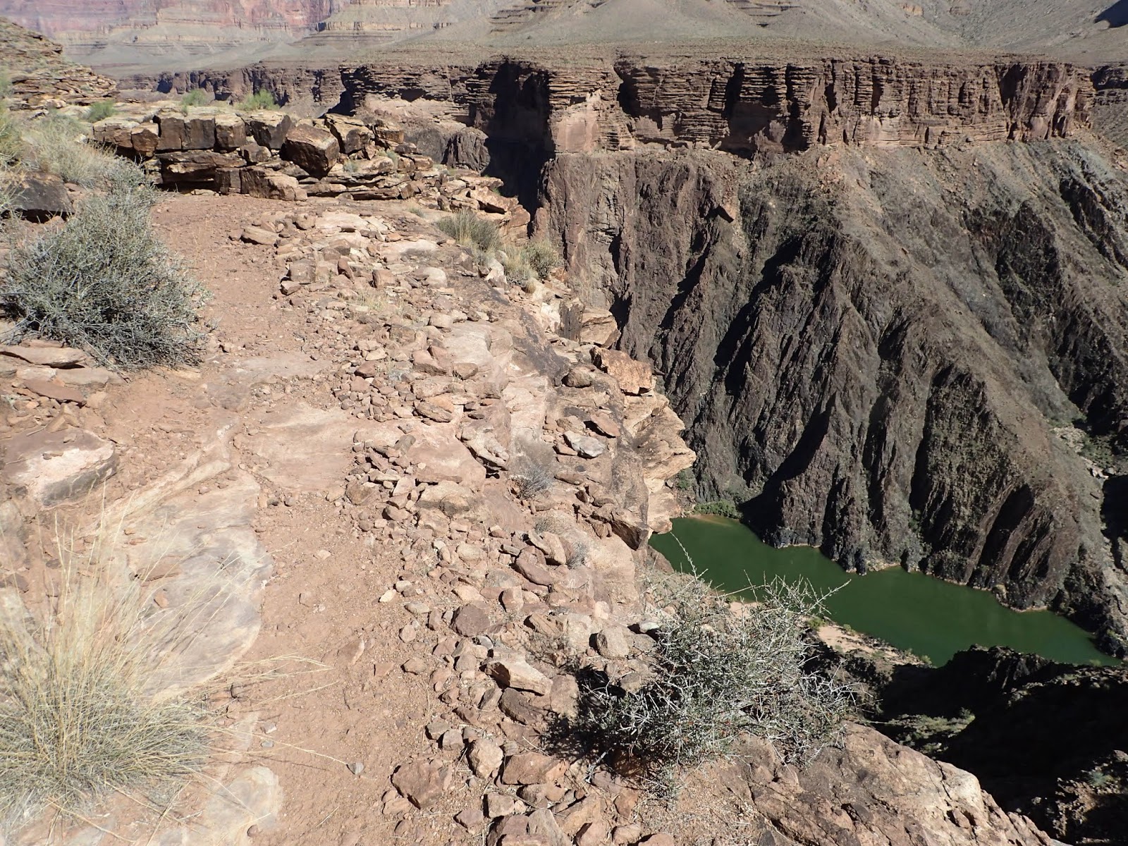
First view of the river
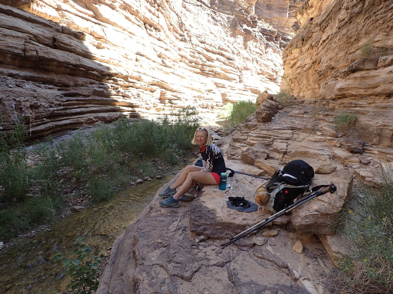
When planning this trip we tried to get a permit to camp at Hermit campground. And by campground they mean you get pit toilets and some flat areas. However, it was full. We could only get a permit for Hermit Rapids, which was 1.5 miles further down Hermit Canyon - at the Colorado River. The camping there was wherever you could find a level bit of sand. And the trail down to the rapids was mostly washed away - so sort of a guessing game. Just follow the creek down.
 That canyon down there is Hermit Creek. Campground is at the very left side
 More awesome trail
On the way down the Hermit trail is a series of tight switchbacks. They are a bit of a mess today. However, we saw a picture of a postcard from back in the day when they had mules taking tourists down here. The trail was wide and flat then - like the top of South Kaibab. Hard to believe when you see it today.

Top of the switchbacks. You can see a downward traverse in the distance


Here the trail ain't so nice


The switchbacks take you down that light colored, diagonal crease in the middle

Down to some more "friendly" trail

Intersection of Tonto and Hermit trails

Heading down to Hermit Creek

That's the creek down there. We have to get down there first

Down to the creek

Some pretty nice trail


Down in it

The rock layers were super cool
Lunch by the creek

Looking up from the creek


This "trail" required lots of route finding and creativity


We picked the wrong way and had to go down this crease

Trail? Sure, whatever.

Always nice to see water in the desert

The mighty Colorado!

Hermit Rapids - short, but looked like fun to raft down

Wherever there is sand is a potential camp spot

Nancy chilling by the river
The last few times I've been in the canyon the river running fast and furious and the water was brown from all the silt churned up. This time it was nice and mellow and the water was actually green. Make no mistake, it was still flowing at a good pace and would whisk you down river if you ventured too far in.

Looks rather peaceful

Home for the night

 This is living...
After we had set up camp a couple of guys showed up and set up their camp not too far from us. Then the rafters showed up. There were about 10 or so and they were apparently on a 23 day trip down the river. They were very nice, but it didn't seem practical to fit all of them and us in this relatively small area. Apparently, they did the math and decided they were going to continue on and camp down near Boucher Rapids - which has a bigger beach area. We were kind-of glad to see them go. We were looking more for peace and quiet than partying. We went over to the rapids to watch them go through it. Looked like a lot of fun!

Rafters arriving

Scoping out Hermit rapids

And there they go

They had big boats...

kayaks...

and one guy on a tube
Here is a video of the rafters on Hermit Rapids. Near the end you'll see one of the kayakers fall out of the kayak.
It was a very pleasant night by the river. The rapids added white noise and it did not get very cold.
Stats for the day: 9 miles, 4800 feet of knee destroying descent.

Day 2
While day one was tough, day 2 had the potential to be the toughest of the trip. We would, of course, need to work our way backup Hermit Creek to the Tonto trail. Tonto dips in and out of drainages, but is "generally" not a lot of climbing. Those should be relatively fast miles. However, once we hit Boucher Trail we would have to descend, off track, to Boucher Creek for water, since there was NONE for the remainder of the trip. From Boucher Creek it is a 1.5 mile grunt up 1700 feet of sketchy "trail" to Whites Butte. That was a potential camp spot since there were level areas there.The next opportunity to camp was Yuma Point - another 2 miles away with an additional 1000 feet of climbing. This last section was the one that people talk about when they say Boucher is "dangerous". Our goal was White's Butte, with a stretch goal of Yuma Point.

Breakfast time on the Hermit Rapid's beach

Ready to roll

Heading back up Hermit creek


This canyon was a geologists dream. This particular rock had a bunch of mica

That huge chunk of layered rock fell from far above


Remains of Hermit Camp, which was a big deal long ago

filtering water at Hermit creek

There are camp spots all around the structure there at Hermit Camp

Back on the Tonto trail

We just came out of that canyon


There were some great views of the river from Tonto


We camped at the head of those rapids the previous night
Once we left Hermit Canyon on the Tonto trail we woud hike toward the next canyon - Travertine. We'd have to hike around this canyon (the Tonto trail does a lot of that) on the bottom side, but also on the top side (about 2000 feet higher). From the picture below you can see the sort of waterfall that we have to hike around in the bottom side, but also way up high is where we would pass by later in the day.

How are we going to get around that?
 Around the waterfall. You can see trail on the other side

Climbing back up the other side of Travertine canyon

The rock up on the right provided shade for a snack break

We'll be up there somewhere in a few hours

A break with a view

Boucher Rapids in the distance
Even Tonto has some wicked exposure. Quick way to the river
Despite getting off trail a few times (it was surprisingly easy to do) the miles on Tonto went pretty quick. Before we knew it the intersection of Tonto and Boucher was in sight. Since Boucher creek was the only water source for the remainder of the trip we decided to drop down and fill every container we had with water. That meant we'd be dragging heavy packs up 1700-2700 feet of climbing (depending on where we stopped) for the day. Yay.

You can see Tonto going down to the right and Boucher going up to the right

This trail intersection didn't even have a sign

Down we go, in search of water

Filtering at Boucher creek

Snack/break time

More lovely trail, back up toward Boucher

On Boucher, looking back at the creek we came from

Pretty imposing red cliffs

We are going up there, in the middle of the picture

More awesome "trail"

some fun climbing

The green crease to the right is our path to Whites Butte

Still smiling? Really?

And up that mess

A little overhang with rock chair to get out of the sun. it was pretty warm by now

Make it stop...

Up on White's Butte
We reached White's Butte at about 2pm. So, it took us 1 hour and 10 minutes to do 1.5 miles and 1700 feet of climbing. That was a much faster pace than I expected given the steepness and condition of the trail. We had originally planned to get here and assess whether to stop for the night or continue on. Nancy didn't even break stride...

Onward to the upper part of Travertine canyon
I was not really sure about how the next section of trail would go. I thought we'd basically go around the canyon head and continue on around at the same level. But I was completely wrong. Instead, we headed over to the head of the canyon and then went up 1000 feet to get to a higher level - where we would find a camp spot at Yuma point.
Soon after White's Butte we ran into a guy out by himself. Turns out he works for Rogue Panda in Flagstaff. He was trying out a new backpack that they have developed. We are familiar with this company because we have a few bikepacking bags from them. Small world.
Once we reached the head of Travertine canyon it was time to climb once again.

On this stuff poles can be more of a hassle than a help
In our research of this trip there was a lot of intel about the Boucher trail. It is apparently suffering from neglect. Since it is lightly traveled, the park doesn't do much work on it at all. The climb from Travertine canyon to Yuma point is rated as double black diamond and most things I read said it was better to ascend than descend. Yet we ran into two groups of people who went down this descent. My impression is that going the way we did was much safer. The trail here is mostly loose gravel so traction is very iffy. Then there are lots of little rock climbs plus one section that is a hands and feet rock climb. For all the stuff I read about this section I was a little disappointed to find it was only like 40 feet long. But it was a fun little climb.

So that is the "big climb"

Nancy handling it, no problem

Yeah, and plenty of exposure. No screwing around here.
By the time we made it through this last climb, my energy level was way down. I was ready to be done. But we still had some more gradual climbing on the edge, with the usual washed out trails and scary exposure. Then, all of a sudden, we were up on Yuma point. And there was the bestest campsite waiting. And it was all ours. Oh yeah.

Tent is going right here

We are only about 1000 feet below the rim

To the very right (the light green patch) is the saddle at Whites Butte that we came across earlier

We came up from the head of Travertine canyon down there
Our "kitchen" area

What an amazing place to spend the night

The view from our tent
Stats for the day: 11.5 miles, 4500 feet of climbing

Day 3
We were up in time for first light, though Nancy stayed in the tent to see the sun actually rise from her sleeping bag - because, why not? We knew we had somewhere around 6 miles for this final day with no real climbing until the last 1.5 miles where we'd gain the remaining 1400 feet - so no hurry. It is hard to show in pictures how awesome this campsite was. Definitely in my top 3 ever.

Here comes the sun

Sleeping in

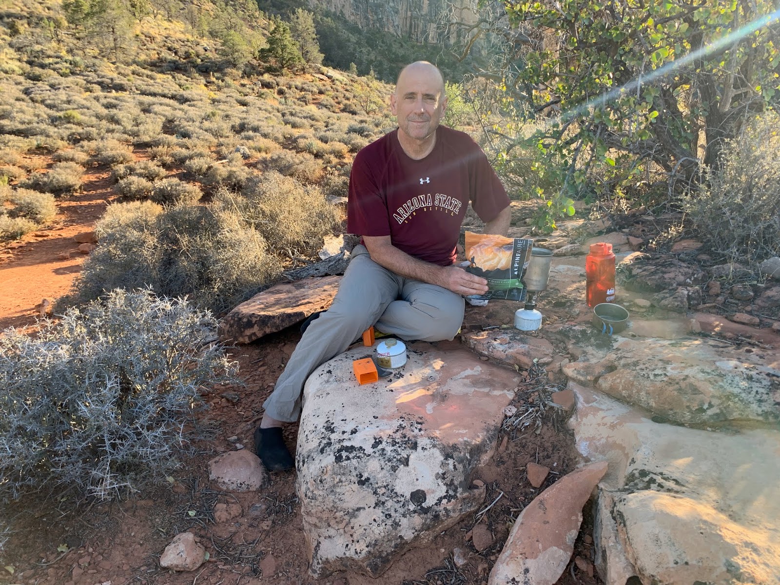
Breakfast with a view

Let's get going
The trail from Yuma point to the Dripping Springs trail doesn't have much elevation change, but it also is in less than ideal shape. I thought we'd rip right through this section, but it turned out to be somewhat slow doing due to rockfall and scary exposure, complete with washed out trail sections. I'm very tolerant of that sort of stuff but there were sections that had me wigged out a bit. It required full attention in spots so that that we didn't end up in that book about deaths in the canyon - Ray knows the one I'm talking about.

And going we got

And soon the trail turns to junk

Fun stuff


Boucher on the left and Hermit on the right - in shadow

You can see the trail above the cliffs
However it wasn't all bad. As we neared dripping springs there was a nice easy rolling section that was quite scenic.

Top of the white rock on the other side there is our destination

There is a spring about a mile up the Dripping springs trail. We were fine on water so we headed back toward Hermit.
On the Dripping Springs trail we ran into a group of mostly younger folk. They had big packs and were headed toward Boucher Creek. Seemed rather late to be starting out for that. Hope it went well for them.

The big group is on the other side in the middle
It wasn't long until we hit the intersection of Hermit and Dripping Springs trails. From here it was backtracking on the section of trail we did on the way out - 2 days earlier. A measly 1400 feet of climbing to the car.

and up we go

no one said it would be easy

Some mighty fine trail work on this short section

Not so much here

I can feel it getting closer

Home Stretch
And just like that, it was done. We piled into the car and headed for Mather Campground, where for $2.50 you can get the most glorious 10-minute hot shower ever.
Day 3 stats:5.4 miles, 2000 feet of climbing

Epilogue
This is a legit hike. I do recommend it to anyone with a sense of adventure who wants to see the west canyon. I believe that Boucher is safer and easier doing this in the direction that we took - counter clockwise. Ideally, you'd get a permit for Hermit Camp (not so easy to do) and just go down to Hermit Rapids without packs. That would make it less of a big day 2 to get to Yuma point. And Yuma is well worth getting to!
Entire loop here:

I'm happy to provide a GPX to anyone who wants to do this.
